I drove to Organ Pipe Cactus National Monument where I camped for the night. I had a bad headache and the sky became quite overcast so I didn’t appreciate it at its best. Still, it’s a wonderful desert setting surrounded by beautiful mountains and many desert plants. The Saguaro cactus of course dominate as they are so tall, but this park is known for its organ pipe cactus, which are common in Mexico, but this is the only part of the United States where they grow. The organ pipes are smaller than the Saguaros, and they grow in clusters from a base on the ground. Unlike the saguaros, they don’t have branches.
It was cool and windy in my tent that night, but I’m not sure that even went below freezing.
I drove on back roads down close to Nogales, but didn’t see any point in putting up with the hassle of crossing into Mexico. At one state park (Patagonia Lake) I went for a hike through all kinds of desert scenery. It was so peaceful being out in the desert alone with occasional deer or hares, etc. I returned along a desert river that was an oasis of green attracting many birds. I recognized a pair of cardinals, but people come there from all over the world to see hundreds of different species. It’s apparently a birders paradise.
Then I took the very rough twisty dirt Ruby Road through the mountains and some incredible scenery. It was quiet, but there were other travellers going through, and many, many border patrols in the area looking for illegal immigrants and smugglers. Ruby itself is a ghost town. I didn’t stop to visit due to shortage of time and an admission fee. The scenery around it for me was the main attraction.
I was up early to drive the more normal route to Chiricahua, getting close to it as the sun came up. It was very quiet, but I was able to drive into the national monument and go as far as the camping grounds, which had a fair bit of snow in large patches. There was a gate closing the roadway beyond the campgrounds, so I parked and walked in.
It was a lovely walk along the roadway with no cars and no other people, with bright sun shining off the tall rocks, and with trees and rocks towering overhead. The rocks seem to be like giant figures, reminding me a little of the rock formations at Montserrat outside of Barcelona. I took many pictures, and walked the gently climbing road, enjoying the solitude.
At one point, a ranger drove up to me just to check on me. He said it was no problem for me to be walking there, but had seen my car and wanted to make sure it didn’t belong to some hiker who had had a mishap.
It was too far to walk to the end of the road where there is apparently a nice overlook, but I walk several kilometers and enjoy the scenery.
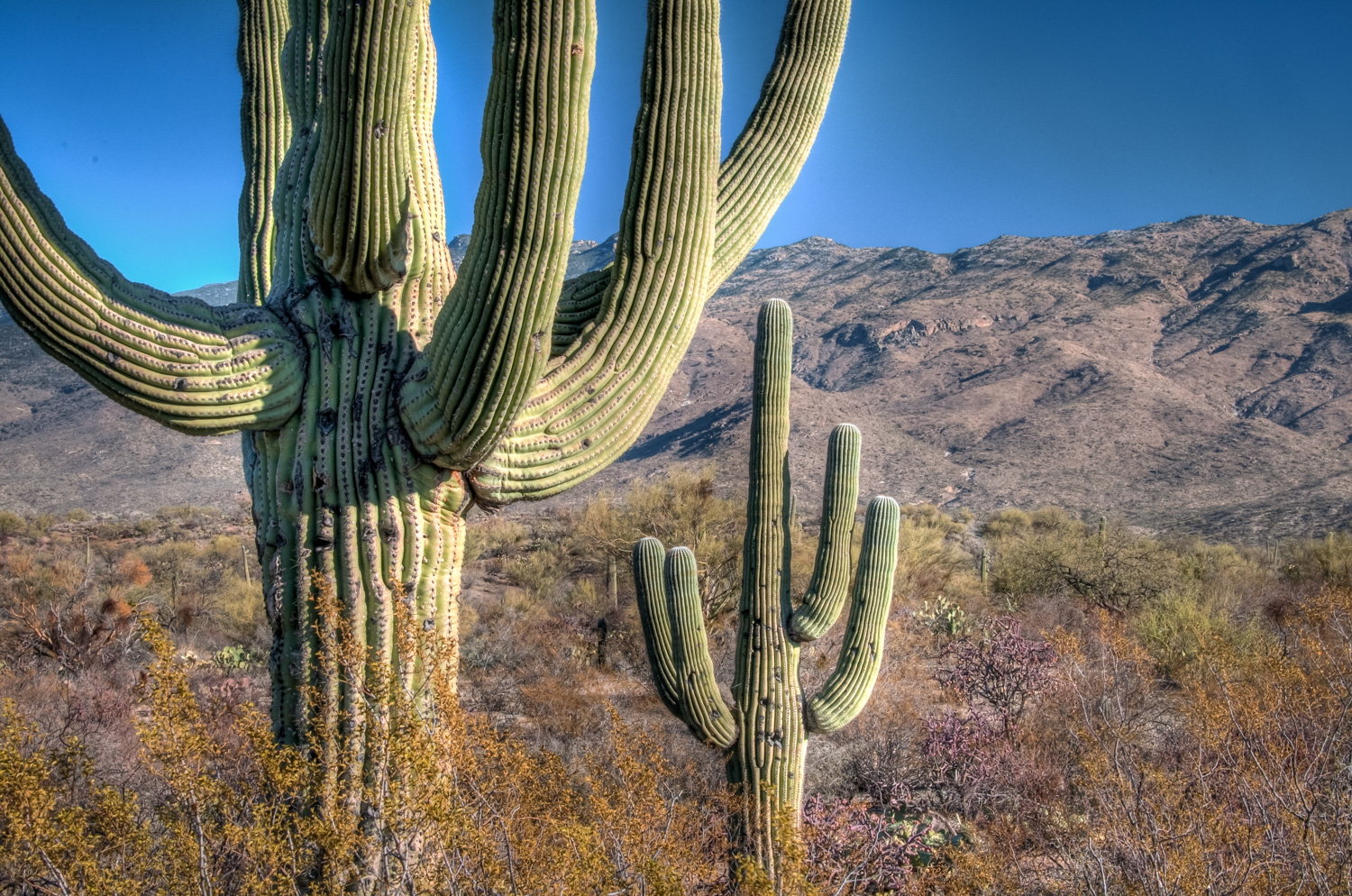
My other excursion on that beautiful sunny Christmas Day was to visit Saguaro National Park outside of Tucson. Its purpose is to show off the Saguaro cactus and its desert environment. There’s a short ring road that you can drive making regular stops and pull offs to explore and admire the desert. The tall Saguaro cactus make dramatic shapes pointed up to the sky, and many other desert plants grow in these hills and valleys at the base of some brown mountains. Here too, I did a lot of walking but no major hikes, and stayed until the sun set behind the cacti.
Tall saguaro cacti stand up in the desert at Saguaro National Park east of Tucson, Arizona. The park also has a western portion on the other side of the city.
Finding a motel was not a problem, but finding a place to eat on Christmas day always is. I ended up going to that old standby, the only place I’ve ever found open for meals on Christmas day in the US, the Waffle House. There I had a nice Christmasy cheeseburger cooked on the open grill.
Here are a few notes and photos of my travels last week:
Tuesday, December 22, 2009
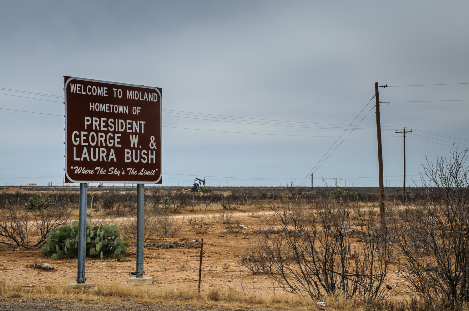
I left the interstate system finally at Midland, Texas, to take smaller roads up to Carlsbad, New Mexico. My sister jokingly suggested I should look up George Dubya Bush while passing through Texas. The best I could do was to snap a shot of a sign at the edge of Midland proclaiming the city’s claim to fame – the hometown of George W. and Laura Bush. The sign was surrounded by tossed beer bottles, stubbly cacti, and there were a few oil wells in the distance. I wonder what kind of impact this sparse environment had on the former president.
A welcome sign next to the highway greets motorists entering Midland, Texas. It’s dry country with oil and its claim to fame is hometown of George W. and Laura Bush. (Richard McGuire Photo)
Even the smaller roads I took were mostly four lanes with nice straight, flat lines and comfortable speed limits of 75 mph (120 km/h). No need to speed, even though there were few places cops could hide. This is certainly oil country and you can smell the crude as you drive through.
Crossing into New Mexico, the communities seemed poor with small, ramshackle houses, even though they were surrounded by oil wealth.
Wednesday, December 23, 2009
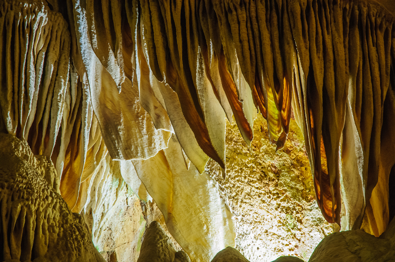
It was a crappy cool rainy day, which made it a perfect day to visit the caverns at Carlsbad. Outside, it was a cool wet 6°C with blowing winds. In the caves, it was comfortable and closer to 16°C. I’ve visited a number of caves around the world in places like Belize, Guatemala, Mexico and Slovenia. These caves were very impressive for their immense size and huge rooms. Although some rooms contained quite a number of “decorations” of stalactites and stalagmites, these caves were probably not as impressive in that regard as some others I’ve seen. They were tastefully lit with plain lighting, and there was an elaborate network of walkways that made much of the caves wheelchair accessible. There were no toilets underground, and had I known that I might as consumed less coffee that morning, but fortunately there was an elevator at the midway point back to the surface. I walked a couple miles underground and took a number of photos with a tripod.
The Carlsbad Caverns are a huge network of limestone caves in southeast New Mexico. What impressed me most about them was their immense size. This photo was used by the U.S. Postal Service on a stamp in a series commemorating the 100th anniversary of the National Park Service in 2016. (Richard McGuire Photo)Some of the rocks in Carlsbad Caverns assume strange shapes and textures. (Richard McGuire Photo)
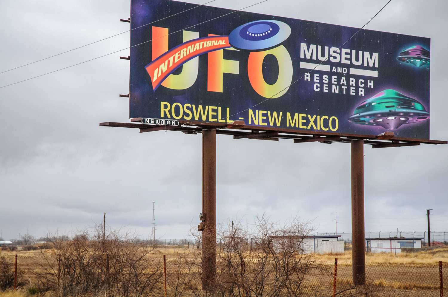
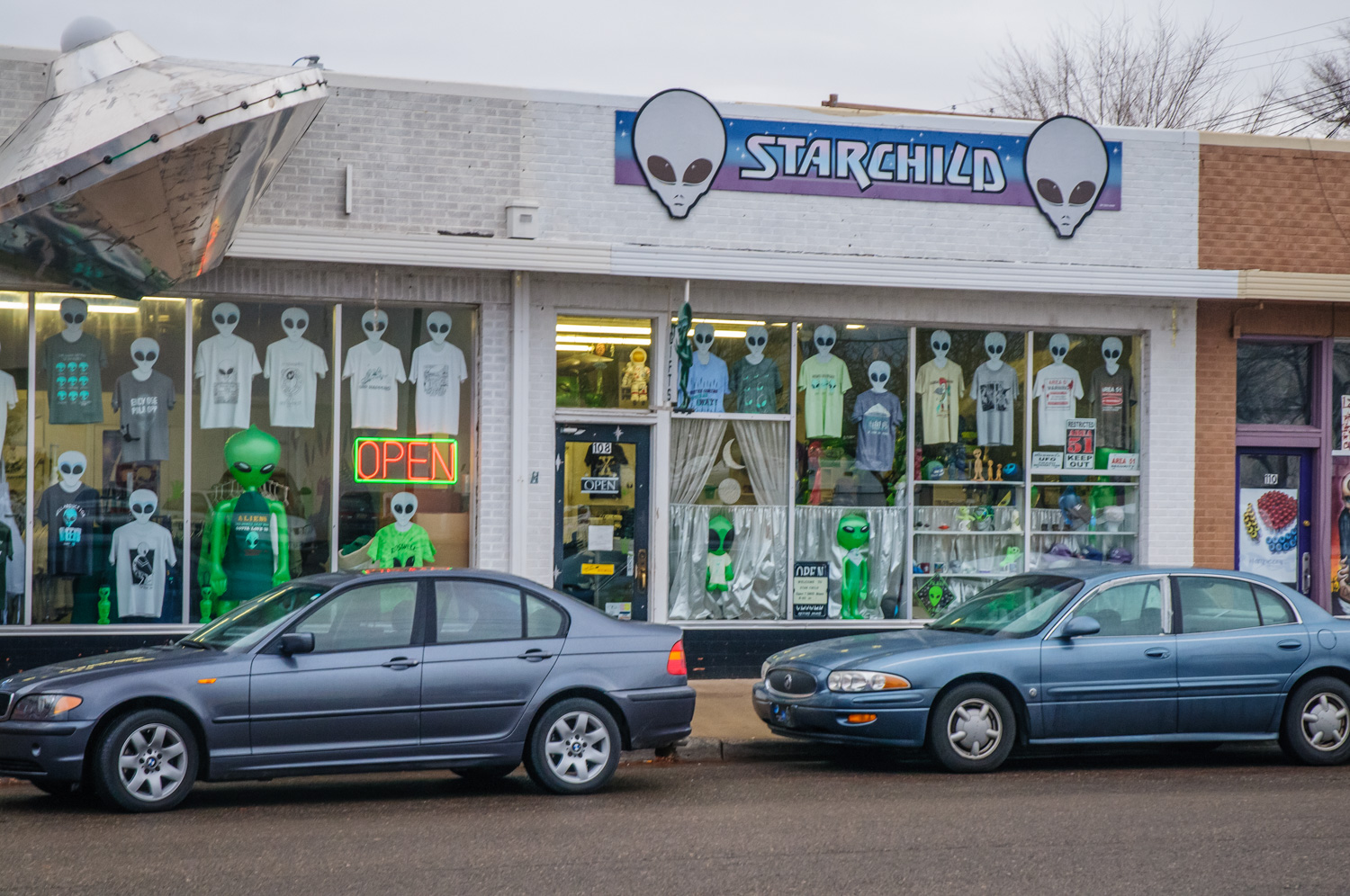
Desert communities aren’t designed to handle volumes of rain, and when I drove back into Carlsbad, a number of the intersections were flooded and vehicles drove through streets like rivers. I carried on north to Roswell, which is repeated to be the site of a UFO crash in 1947. They’ve exploited this for tourism, and there are shops with pictures of little green men with big heads. There is an interesting museum documenting the incident and exploring the UFO phenomenon in general. It has newspaper clippings from the time, photographs of people involved, and affidavits signed by people who were either direction or in direct witnesses to events. I maintain an open mind but healthy skepticism about various UFO claims. In the time I spent there, I didn’t see anything that absolutely convinced me this was a UFO and not some other incident, for example the failure of the weapons test. I was convinced however, that the official explanation that it was simply a weather balloon was a hoax, and there was an official cover-up of what did actually happen.
When I left the museum it was snowing hard and the roads were slushy. I had planned to continue on to Alamogordo, but that would have entailed driving a couple hours in the dark on a mountain road in the snow. So instead, I got a motel in Roswell. That meant I would not be able to see White Sands National Monument at sunrise the next morning as I had hoped.
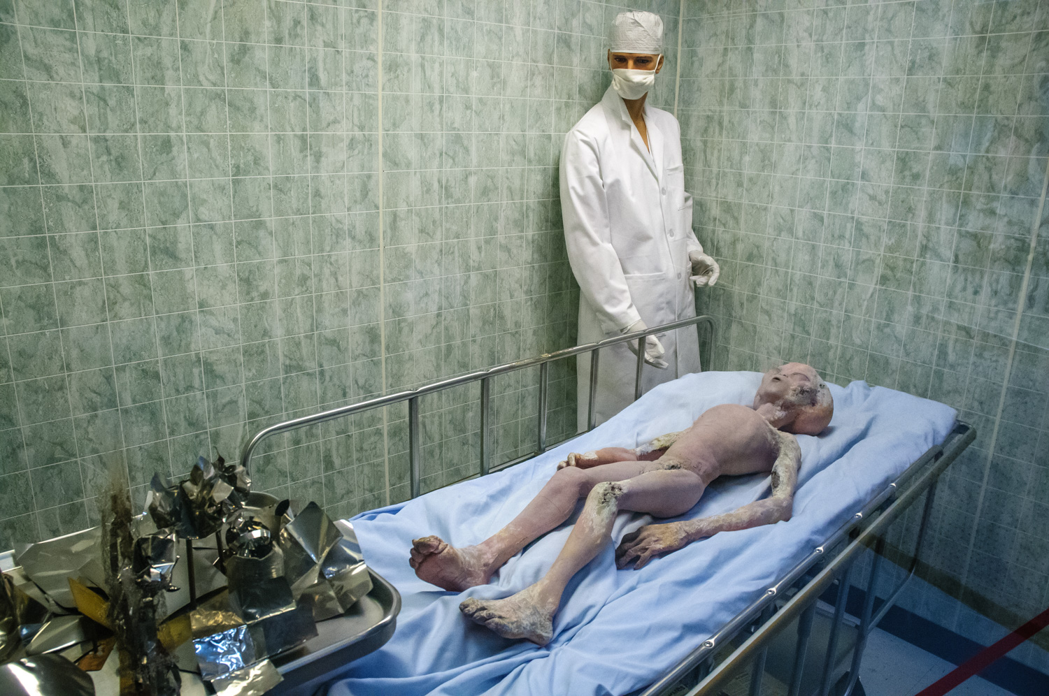
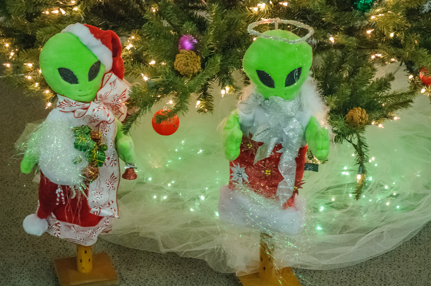
Roswell, New Mexico, is said to have been the location of a UFO crash in 1947. Although the U.S. military claimed at the time that it was just a weather balloon, the Museum and Research Centre in Roswell suggests there may have been a cover-up. (Richard McGuire Photo)A replica of an alien involved in a crash landing at Roswell, New Mexico, in 1947 is on display at the UFO Museum and Research Center. (Richard McGuire Photo)Green aliens were dressed in Christmas outfits under the tree at the UFO Museum and Research Center in Roswell, New Mexico. (Richard McGuire Photo)Roswell, New Mexico, is said to have been the location of a UFO crash in 1947. A store capitalizes on this history. (Richard McGuire Photo)
Thursday, December 24, 2009 (Christmas Eve)
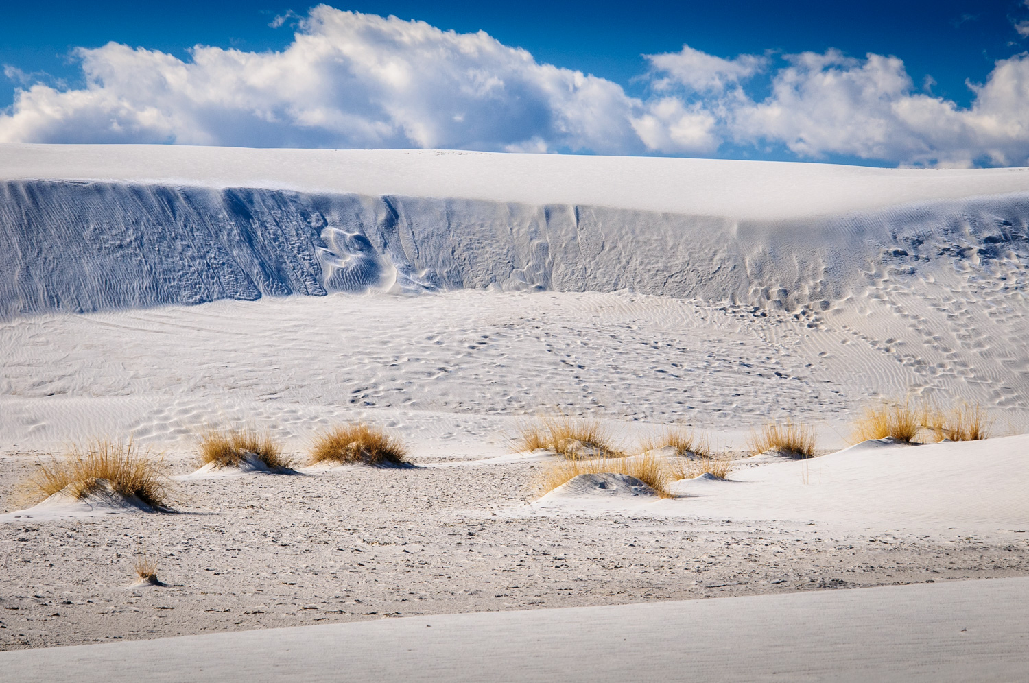
There was still snow and ice on the ground when I left Roswell. The motel woman said snow that stays on the ground is very rare there. After crossing the scenic mountains, I arrived at White Sands National Monument. The sand dunes are fine gypsum sometimes packed quite hard, and sometimes soft. I took a couple trails over the dunes looking at the small scraggly vegetation that survived among them, and reading plaques about how animals survive there on little moisture. The glaring white in the sun often looked like snow, except it was much warmer.
The white sand at White Sands National Monument in New Mexico drifts like snow, constantly shifting.
From there I drove directly westward, through Deming, and into Arizona. My plan was to make it to Chiricahua National Monument. Here I experienced the folly of blindly following a route suggested by the GPS. Had I noted more carefully on one of my maps, I would have seen that the route to GPS was trying to take beyond was marked “closed in winter”. At first I was on a nice flat paved road heading through open rangeland and crossing periodic cattle guards, or “Texas gates” as they’re called in Alberta. Soon the road turned to gravel and I began to climb higher into the mountains. The road got narrower and narrower and rougher and rougher and I passed through a semi-ghost town called Paradise and noticed there was a lot more snow around. The road got steeper and steeper, the snow got deeper and deeper, and the mud got thicker and thicker. On one particularly steep stretch, my wheels spun and I realized it would be stupid to continue further. The road was too narrow to turn around, so I had to descend about a half a kilometer in reverse before I found a safe place to turn around. I retraced my route, and as it got dark, I realized my best bet would be to find accommodation in the town of Willcox and head for Chiricahua early the next morning.
The Southwest United States is renowned for its spectacular desert landscapes and mountains, and is a favourite location for landscape photographers. Over the years, I’ve seen beautiful images from this region in some of the photography magazines that I read such as Outdoor Photographer.
And so I decided to drive to this region over the Christmas break instead of traveling to a more distant tropical location. It’s a lot of driving from Ottawa — four days straight driving just to get there — then more time driving between locations that tend to be quite distant from each other. People asked me whether it would not be more economical just to fly. Perhaps. But I am carrying camera equipment and camping equipment that would be a nightmare to take on any plane. Then, once I got here, I would still have to rent a car, and it’s extremely difficult to rent a standard, and it’s even harder to rent a car with snow tires. Both of those are necessities for traveling to some of the rugged places I wanted to go. I’d rather have my own car – which goes 1,000km on a $40 diesel fill up.
Added to that, I despise air travel, especially in the United States. The aborted bombing threat over Christmas, and the resulting security nightmares, remind me just how unpleasant air travel has become. I’m sure it’s only a matter of time until a terrorist smuggles explosives in a body cavity, and from that day onward, security will be checking all air passengers’ body cavities before they board the plane. I hate air travel.
Driving has its own challenges, not the least of which is weather. I delayed my departure by a couple of days thinking the weather would still be okay when I left, which was. What I didn’t notice until it was too late, was that a massive snowstorm was heading for Washington DC just as I reached that area. I had to stop early the first day at Hagerstown, Maryland, when the highway became virtually impassable. There were thousands of cars in the ditch in the area. The next day, the snow had stopped, but the roads were still covered, and I had to take smaller roads to get out of the mountains and choose a more southerly route through the Deep South. Instead of going through Tennessee and Arkansas, I went through Georgia, Alabama, Mississippi, Louisiana, and met up with my original route in Dallas.
You don’t experience the United States in any great depth when you’re simply driving all day on the interstate. Yet you get glimpses when you stop your meals, gas, rests, or pull into small towns in search of some forgotten or needed item. This trip, I’m using a GPS, which is wonderful for telling me when I need to turn and what lane to be in. It makes navigating the freeways easier, especially going through cities. It even detects traffic congestion and chooses detours for me. Sometimes the detours are even fun as when I was led through some of the more upscale neighborhoods of Montgomery, Alabama, or through some small towns to bypass shut-down traffic on a freeway.
I brought camping gear, and though I have camped, it’s not the best for taking advantage of the short daylight hours. It’s often dark by five, but some days on the road I preferred to drive till nine or 10 at night and then grab a motel. Fortunately, this being off-season, cheap motels are available. The Motel 6 chain is very adequate and their rooms range in price from $27 up to about $40. Clean and basic, but all the necessities such as clean sheets, hot showers, and wireless Internet — not necessarily prioritized in that order.
At last, after four long days of driving, and numerous meals at Waffle House or sandwiches at roadside rest stops, I arrived in Carlsbad New Mexico, ready to begin exploring the Southwest.
Southwestern Ontario, especially along the north shore of Lake Erie, is a unique corner of Canada. Because of its southerly latitude and the climate modifying effects of shallow Lake Erie, it has a climate and vegetation unlike that anywhere else in Canada. In fact, they refer to the tall deciduous forests as “Carolinian” because of their similarity to the Carolinas in the U.S.
It’s often referred to somewhat jokingly as the “banana belt” because of this climate. Of course no bananas grow, but you’ll see trees like cottonwoods and other more southerly species. And the farms grow products like tobacco and tomatoes. At Point Pelee, the southern tip of mainland Canada, my GPS showed a latitude of 41º 54′ 32″ — roughly the latitude of Istanbul, Rome, Barcelona and northern California.
Like many other parts of southern Ontario, away from the areas that have been filled with urban sprawl in recent decades, southwestern Ontario has many old Loyalist communities with beautiful old stone buildings.
Other than one brief previous journey, I’d never really visited this region before, except passing through on the 401 freeway. This was a chance to get onto the back roads and photograph some of the rural settings.
Here are a few shots I took of the area. I selected these to be representative, and they aren’t necessarily the best shots.
I began this blog for the one-time purpose of a trip to Central America in the winter of 2008-09.
It’s now time to give it a new life.
I plan to write about my interest in photography, and also about the subjects of my photos — often the backroads of Ontario and Quebec, or the streets of their cities.
I am currently on a trip to southwestern Ontario, the shores of lakes Erie and Huron, a part of Ontario I know the least.
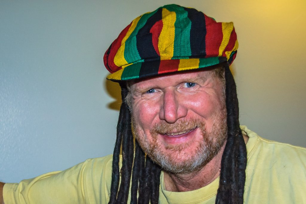
Despite the temptation, I did not wear my “natty dreadlocks” when I boarded the plane home. Nonetheless, it may have been my scruffy appearance that caused me to be flagged for a secondary inspection. (Richard McGuire Photo)
Travel tends to change one. Of course it’s always hard to return from a trip and pick up where you left off.
As I began to unwind from a stressful fall, I began to let my hair down, so to speak. In order to shave, I need a mirror and hot water, and most of my hotels were missing one or both of those, so I decided to grow a beard. And, I picked up a set of natty dreadlocks.
Should I be surprised that when preparing to board my connecting flight in Chicago, the security people took me aside and told me my airline had requested that I be given a secondary inspection?
“Is this random, or is it because I have a beard?” I asked the guard.
“It’s because you look like a terrorist,” he said, smiling, and then adding that there actually are many reasons an airline might call for this — ranging from purchase of a one-way flight, paying cash, etc. “Do you have any ticklish spots?” he asked, preparing to feel me up.
It was that kind of a trip home. First, I got to Cancun airport well ahead of time, which was a good thing, as the line-up to check in was more than an hour long in a hot building. Then the departure of the flight kept being pushed back while mechanics worked on the plane. We finally left, two hours late, when I only had an hour and a half in Chicago to clear immigration and customs, change terminals, get inspected, in make my flight. Needless to say, I missed my connection, as did many others.
When I talked to the American Airlines people, they told me they had me on a new flight going at 9 a.m. Saturday. In other words, I would have to spend the night in Chicago. But she checked, and lo and behold, there was a flight with United going later Friday night, and I had plenty of time to make it. I would get into Ottawa just after midnight.
All was well until I arrived in Ottawa, and waited for my luggage to come down the carousel. I waited and waited until I was the last person, and they shut down the belt. It never came. After filing a claim, I now faced the task of getting home in minus 26-degree weather without even my jacket, which was in my luggage.
Fortunately, I got a taxi right away, so didn’t freeze for long. But I didn’t get to sleep until close to 3 a.m. And United gave me very little information about my luggage until they told me Saturday night that they’d located it. They finally delivered it to me Sunday night.
So here I am back home, and all set to return to work. I haven’t decided how long to keep the beard, but I won’t wear the dreadlocks. They are just a crude wig made from cotton in Guatemala, and sewn into a Rastafarian hat to sell to tourists.
I’m now in Cancun in the same hotel where this adventure started exactly five weeks ago. This afternoon I fly to Chicago and then on to Ottawa, if my plane doesn’t hit geese and try to land on Lake Michigan.
Mid-January is not a great time to return to Canada, but I’ve been blessed with several weeks of great weather while most Canadians suffered in cold. Still, the weather in Ottawa looks to be right now about the worst of the season. And never in my wildest dreams did I think a transit strike in Canada’s capital would be allowed to go on for five weeks. My arrival will be lots of fun, because I left my winter coat at home.
When people down here ask about Canada, they know it’s very cold and there’s lots of snow. But most, except those who’ve been to North America, have no real concept of it. Ice is something you put in drinks, and they’ve seen snow on TV, but here if it goes down to 15C, people say it’s cold. One British expatriate in Belize just shook his head when I said it was minus 20 in Ottawa that day: “Why would anyone live there?” Good question, though I do love those few weeks of tulips and autumn colours.
I’ve met several retired or semi retired people from North America who live down here. At Lake Atitlan in Guatemala, which must have one of the best climates in the world, I met Ron, who retired there and rents a two-bedroom house for less than $100 a month. He says he could never afford to live on his pension in the U.S., but here he lives well. He strikes up conversations with tourists, and he lives with two females — a dog and a cat. The four-legged kind of female, he says, is much more affordable than the two-legged kind.
Another semi-retired man, originally from Alberta and Saskatchewan, who I met yesterday on his way to Belize, lives in Puerto Vallarta, Mexico, and does metal art. He was on his way to Belize to look into setting up a store in the tourist zone where the cruise ships arrive. He spends his summers in Ketchican, Alaska.
Returning to Mexico is interesting after Guatemala and Belize. It seems so developed and relatively first world, even outside Cancun. The poverty and crumbling infrastructure in Guatemala and Belize are a sharp contrast to Mexico’s relative prosperity. Of course, traveling the other way, from north to south, Mexico’s poverty compared to Canada and the U.S. is more evident.
Soon it’ll be time to head to the airport. I don’t feel ready.
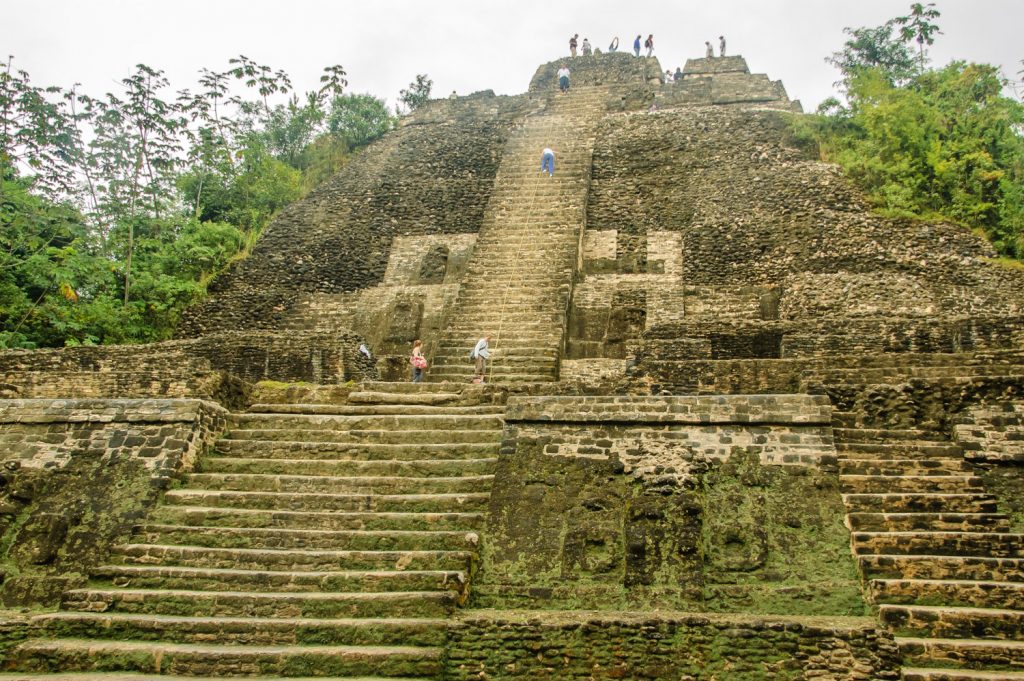
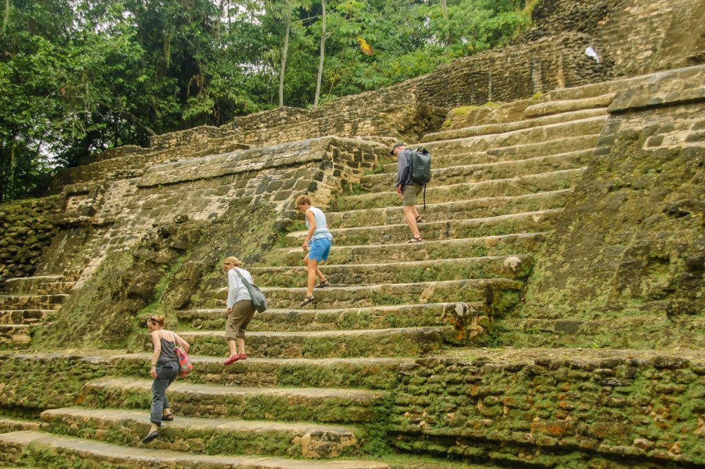
Tourist climb the pyramids at Lamanai, an ancient Mayan city whose name means City of Submerged Crocodiles. It’s a long boat ride up the New River from Orange Walk. (Richard McGuire Photo)
From Dangriga, I took a long journey north about seven hours, passing briefly through Belize City to change buses, to Orange Walk. The journey took me up the scenic and mountainous Hummingbird Highway, but the north itself is quite flat. It’s a mix of farm country, largely sugarcane, and wilderness.
Orange Walk is a community mainly of mestizos and largely Hispanic, though the surrounding area has a number of Mennonites. And of course almost every store and restaurant in Orange Walk is run by Chinese. It’s also the starting point for a river trip to the ancient Mayan city of Lamanai.
I arrived Monday night and booked a place with a small group going with a guide on Tuesday. Unfortunately, Tuesday started off as pouring rain, and I was soaked before I even found a place for breakfast. A German couple at my hotel backed out of the tour, but I figured, and the local people said, that the rain wouldn’t last and would soon clear up. I figured wrong.
I enjoyed the trip nonetheless, but was completely soaked. I wrapped my camera in plastic, but everything else got wet. The rain did let up for a while at Lamanai, but it rained continually during the river trip there and back.
The guide, Melvis, took me alone about seven miles up the river before we met five other tourists who were also coming. Along the way he pointed out bird after exotic bird in the thick foliage at the sides of the river or flying overhead: many herons, including great blue, who migrate from the north, a rare tiger heron, snowy egrets, parrots, a keel billed toucan, vultures, and numerous others. Melvis knew his birds. The river is infested with crocodiles, but as Melvis explained, in the cooler rainy weather, they tend to remain submerged in the water, rather than sunning themselves on the banks, as they do normally. Still, he saw one slip into the water, though I missed it.
Lamanai’s name, according to one interpretation of the Mayan languages, means City of Submerged Crocodiles. It’s an appropriate name, given that crocodiles seemed to have spiritual significance, and were certainly present.
The city itself consists of many hundreds of excavated, partly excavated, and buried buildings. There were a couple impressive temples, one of which I climbed on the steep stone steps, but generally there was less to see than in other cities such as Tikal. It was the setting in the jungle at the end of the winding river journey that made it an interesting experience.
Today, Wednesday, I took a short journey to the seaside town of Corozal, just south of the Mexican border. I’ve spent the day getting organized and ready for the long trip north. It was actually cool here today, unusually so, and overcast. This may be the southern edge of the cold system that has much of North America now in a deep freeze. I dread the return to the frozen north.
Tourist climb the pyramids at Lamanai, an ancient Mayan city whose name means City of Submerged Crocodiles. It’s a long boat ride up the New River from Orange Walk. (Richard McGuire Photo)
The face of a Mayan figure on one of the temples at Lamanai remains fairly intact. (Richard McGuire Photo)Thick, lush forests line the river on the way to Lamanai, an ancient Mayan city in the Belizean jungle. (Richard McGuire Photo)