Canyonlands and Arches national parks, Utah

Friday, January 1, 2010 (New Year’s Day)

On New Year’s Day, I set out to visit two wonderful national parks near Moab — Canyonlands National Park and Arches National Park. I drove to Canyonlands first and as I approached it, I drove into pockets of fog alternating with clear areas of sunshine. The hoarfrost clung to the bushes and trees. It was still dark as I drove to the park, but the sky began to get lighter. It was a cold crisp day, eventually with blue sky, and it turned out to be one of the best days of my trip for photography.

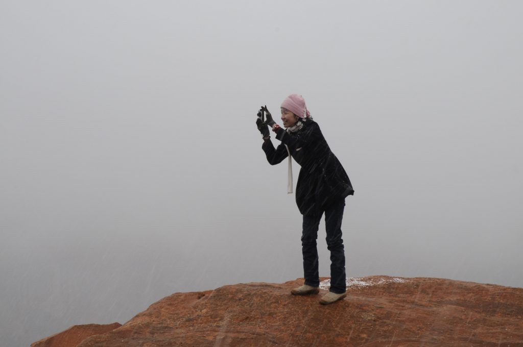
One of the classic photo spots in Canyonlands is Mesa Arch, a stone arch on the edge of the cliff that catches the sunlight at sunrise. It’s about a half-mile hike over a hill, and I trudged up with my tripod and camera along the well trodden path through the snow. When I arrived there were about five or six other photographers already there with their cameras and tripods set up. The sun was just starting to rise, but the valley below was full of fog. It was a beautiful sight. On the one hand, it was disappointing that you could not see any details in the valley, but on the other the fog gave it a wonderful mood in the warm sunlight. For a few minutes I shot some great pictures of the arch and the nearby cliffs in the sunlight and surrounded by fog. Before very long though, the fog rose and we were engulfed in it. A few other photographers straggled up later and were disappointed to see nothing. Some hung around, and others left. I stayed a while and got a few more shots when the fog cleared, but none as good as those first few. I then returned to my car through thick fog with an eerie sun trying to burst through.

Near Mesa Arch, Canyonlands National Park, Utah
Near Mesa Arch, Canyonlands National Park, Utah – © Richard McGuire
Mesa Arch, Canyonlands National Park, Utah
Mesa Arch, Canyonlands National Park, Utah – © Richard McGuire

I drove to several other lookout points and trails to the number of pictures of the fog, the snow and the cliffs. It was cold and crisp, but incredibly beautiful.

The fog hung around well into the afternoon, so I decided to forgo a visit to Dead Horse State Park, which has a beautiful view of the river, but it would have been completely fogged in. Instead I returned to Moab and then set out for Arches National Park, which is quite near.

I had learned that it’s possible to buy an $80 annual pass for all the national parks and monuments, which would have been a better deal than paying individually at each park. This is especially true since many of the more expensive parks are $25 or $20 each. Fortunately, I also learned that if I had kept my receipts I could trade them in towards an annual pass. Being the pack rat is one, I had of course kept my receipts, and that Arches I traded them in for about $55 towards the $80 pass. It was a smart move because the individual admissions by the time I finished my trip would have been well over $100, and now I have an annual pass that the good for any visit I might do to the US in the next year.

Arches National Park had many more people than Canyonlands, but it still wasn’t overly crowded. Its land formations in sandstone were incredible — not just arches, but hoodoos, protruding rocks, and many various shapes. In fact, it was certainly among the more spectacular parks of my trip. It’s quite high up, so there was a fair bit of snow. I didn’t do any long hikes, given the time, but I did some short walks and drove between various pull off spots to photograph the great vistas.

One of the more popular arches is called Delicate Arch, but it involves a steep hike of a couple hours return to get close to it. It was by now past 3 PM, so I opted instead to take a shorter hike to a viewpoint where you can see the arch in the distance from below. This provided some great views, and still left me time to see other parts of the park.

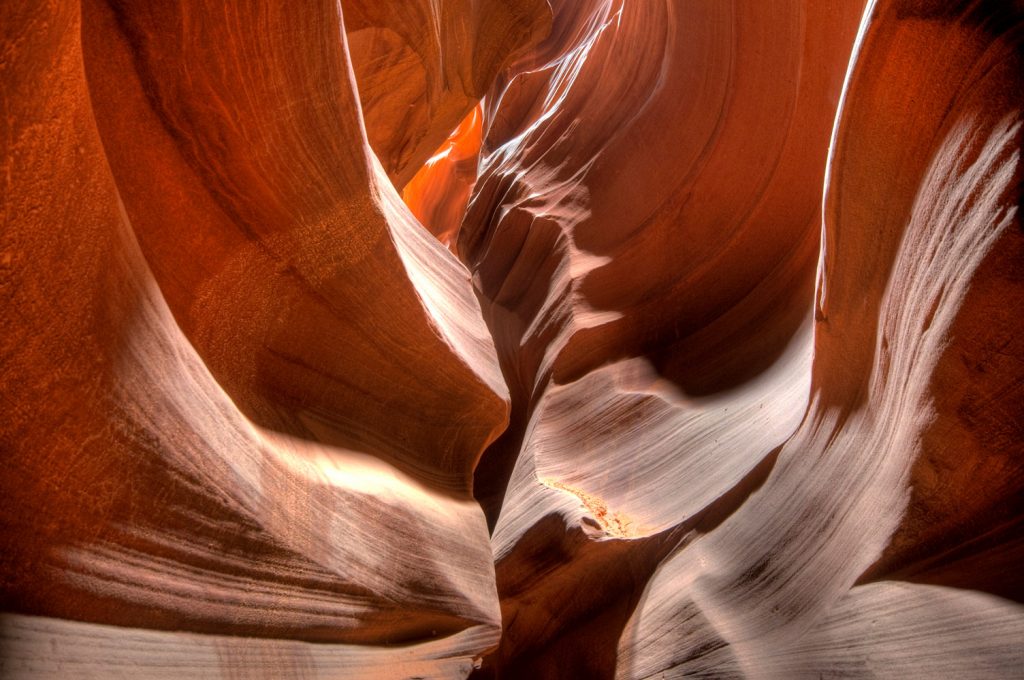
The Fiery Furnace is a spectacular area of rock formations with canyons and fins. You need a hiking permit to visit it, or you can book ahead to take a ranger guided tour. As I had neither, I had to be content to look down on it from the parking area. It was still spectacular with snow scattered across the red sandstone fins.

Skyline Arch, Arches National Park, Utah
Skyline Arch, Arches National Park, Utah – © Richard McGuire

Lastly, as the sun went down, I took a short hike to the base of Skyline Arch, a massive arch in a cliff. In the dusk, the light was blue and it looked great with the snow, the red land formations and silhouetted trees. Here I also shot several nice pictures, as I struggled to keep my hands warm.

Into Utah

Thursday, December 31, 2009 (New Year’s Eve)

When I first saw pictures of The Wave, I was impressed by the curvy shapes of sandstone carved by erosion, the smooth lines, and the blend of warm colours. The Wave is located in Coyote Buttes in Vermilion Cliffs National Monument, in northern Arizona right on the Utah border. It involves a 10 km return hike through the desert without clearly marked trails. The tricky part is that they limit the number of people that can go by issuing permits with only 10 groups allowed to obtain permits four months in advance, and another 10 the day before. The permits are issued by lottery as usually there are more people wanting to go than permits available.

And so, or early in the morning I set out from Page to drive to Kanab, Utah, a couple hours away to be there at 9 AM when the lottery for permits occurred. I had phoned the day before and learned that on Thursday they would be releasing permits for Friday, Saturday, Sunday and Monday because of the New Year’s holiday. This meant there would be 40 permits available, and that the woman told me that if I was flexible on days I had a reasonably good chance of getting one.

As I drove, it was still dark, and I could see a big around the full moon right ahead of me setting behind some buttes, so I stopped my car and shot some long exposures. There was a lot of snow on the ground in many places hanging to the few trees, and a hoar frost clung to many of the plants. When the sun came up the sky was blue, but Kanab itself sat in a thick fog.

Setting full moon, southern Utah
Setting full moon, southern Utah – © Richard McGuire

I found the office that issues the permits, and there were already about a dozen people there. We all selected the days we would prefer, and were told we could switch dates immediately before the draw, if it looked like certain days were full and others were not. I chose the Monday, knowing this would give me a little time to visit other parts of Utah, visiting The Wave on the way back. We counted down to 9 a.m. when the lottery would occur. Although more people trickled in, by luck none of the dates were completely full, and so everybody got their pick without a lottery happening. At 8:59, I joked that there was a bus arriving in the lot, which cost a few chuckles, but fortunately didn’t happen. In fact, the woman said this was one of the few days when everybody got what they wanted without a lottery.

After breakfast of huevos rancheros at a local diner, I continued to drive back to Page via the scenic route to the south. This cross through mountains and there was some packed snow on the roads, but the driving wasn’t bad and the snow glistened on the pines. Descending the mountain, you could see the bold outline of Vermilion Cliffs rising from the desert as a big massive body of sandstone.

Closer to Page, I came to the turnoff for the walk in to Horseshoe Bend, which I had tried to photograph the previous day. It was much sunnier, so I tried again, hiking the half-mile to the cliff’s edge. This time the view of the river 1,000 feet below was very clear. There were numerous Japanese tourists taking pictures of the view and some went right to the edge of the cliff and leaned over for their shots. I suffer far too much from vertigo to try that, so I edged closer to the cliff on hands and knees and got on my belly. Even then, the only way to see the bend in the river, is to actually lean over the edge. Even on my belly, I felt dizzy even attempting this and was unable to shoot a picture this way. At last I attached the camera to my tripod, lay down with the tripod and extended it out over the edge as though it were a long pole with the camera aimed at the right few with a super wide lens. I triggered multiple exposures with a cable release, and got some shots without actually hanging over the edge myself.

Horse Shoe Bend, Arizona -- the obligatory shot
Horse Shoe Bend, Arizona – © Richard McGuire
By now it was getting later in the afternoon, and I had a long drive ahead of me as I planned to drive all the way to Moab, Utah for the night, and hoped to drive through Monument Valley during the day. It was a long drive through the desert on a fairly rough paved road, but traffic was not too heavy, and even though it was getting late I made a reasonably good time. That is, until I came to Kayenta. Here, the road ran right through the town, and speed limit dropped drastically. I slowed down, but not enough. Suddenly there was a cop car behind me flashing his blue and red lights. He ticketed me for speeding, taking a long time to issue the ticket. By the time I finally got going again, it was starting to get dark.

Monument Valley had some attractive buttes and mesas sticking up from the flat desert. But from the main road there were few places to stop and so the photo opportunities were very limited. I understand that to really see the best views you must visit the Navajo Tribal Park, but as it was getting dark this was no longer an option. I stopped and took a few photos of the sun setting behind the buttes and the full moon rising ahead, but I don’t think I did the area justice.

It was quite cold as I set up my tripod for some long exposures in a few of the pull offs. At one, a car stopped right in the area I was photographing. I waited a while, and it still stayed, so I picked up my tripod and walked past it to photograph with a clear view. Behind the car a young Navajo man was pissing a big stream. He greeted me as I walked past and struck up a conversation. He’d obviously had a few drinks. He asked me about my photographing, and in where I was from, and I told him I was admiring the beauty of the land. He said he was always from this area, and the land was very special to him and his ancestors.

Monument Valley, Arizona, at sunset
Monument Valley, Arizona, at sunset – © Richard McGuire

It was a long drive the rest of the way to Moab, and I got the feeling I was missing some spectacular scenery in the darkness. I arrived and checked into the local Motel 6. I was tired, and then sat up for a while going through my pictures and sending e-mails, but didn’t pay attention to the new year and decade.

Antelope Canyon and Horse Shoe Bend (obscurred by fog and snow)

 
Wednesday, December 30, 2009

It was a cold grey day and threatened snow. That didn’t matter for the morning because I had booked a tour with a small group and a Navajo guide for a photography trip to Upper Antelope Canyon. Antelope Canyon is a slot canyon carved by water over the years into the desert sandstone. Its swirls and shapes have impressed many photographers, who make it a destination, as do many tourists.

Our guide was good, and quickly led us to the far end of the canyon to work backwards, and sometimes managed to hold back crowds when we photographed. But it was simply too crowded to do serious photography. I dread to think how much worse it would be in peak season. As the canyon is quite dark you need to take very long exposures using a tripod. For each shot, I took either five or seven separate exposures because the range from light to dark was so huge I knew that the only way to capture all the detail would be by combining separate images on a computer afterwards (HDR or high-dynamic range photography). Unfortunately taking that many long shots meant the odds of being disturbed were huge. Tourists often walked by, sometimes accidentally kicking the tripod. Sometimes their guides shone laser pointers onto the rocks leaving red squiggles on my images. For certain scenes, photographers lined up taking turns moving their tripods into place, sometimes lining up the tripods in a row with the legs woven in and out of each other.

That doesn’t take away from the beauty of the canyon, but it did make it hard to photograph it. In hindsight, I think I should’ve gone to one of the lesser-known slot canyons in the area, including perhaps even Lower Antelope Canyon across the road, which apparently is just as beautiful but much less crowded.

Upper Antelope Canyon, Arizona
Upper Antelope Canyon, Arizona – © Richard McGuire


I wanted to photograph Horse Shoe Bend, a dramatic river bend below a steep cliff south of Page. It was now foggy and starting to snow, but as I didn’t have many alternative destinations, I set out anyway. It’s a walk of about a half a mile from the parking area on a trail through the desert to the edge of the cliff. In what must have been the understatement of the year, one Chinese tourist told me: “The visibility is not very high.” That didn’t stop a number of tour groups from making the walk anyway. Only occasionally did the fog lift just enough that you could see the faint outline of the river more than 1000 feet below. At other times it was just old white of fog and falling snow. Some of the tourists went right to the edge of the cliff and took pictures of the fog. I took a picture of one Chinese tourist woman standing about 2 feet from the edge of the precipice and snapping a picture of the fog.

Horse Shoe Bend in the fog
Horse Shoe Bend in the fog – © Richard McGuire

Grand Canyon, Arizona

Monday, December 28, 2009

I was up early before the sun to take a drive on a circular route through the desert. Unfortunately the sky was still very overcast and the light was flat, so I didn’t get any great pictures, but I did admire the desert scenery and cacti.

This was the closest to Mexico that I got — so close in fact that my cell phone thought I was in Mexico, while in fact I was a few kilometres north of the border. From there I began a long drive north into colder parts of Arizona. Soon I was leaving the warm desert behind me and climbing up into snow-covered forests of Ponderosa pines north of Phoenix, as I reached Flagstaff for the night. Flagstaff was the closest thing to winter I’d experienced since the snowstorm on the journey south.

Tuesday, December 29, 2009

The weather forecasts were for calling for several days of cloudy snowy crappy weather, so I wasn’t sure what to do. I decided to take my chances and go to Grand Canyon anyway, knowing that the option remained of returning if I didn’t see it at its best.

I caught bits of sun here and there, and the clouds even had a bit of drama, but on the whole it was pretty cloudy and dull. The canyon itself though is still amazing — much more vast than I ever could’ve imagined.

Even at this time of year, it was jammed with tourists, and finding a place to park was no easier than West Edmonton Mall on Boxing Day. I would hate to see it at peak season. Sometimes I have to laugh at the antics and behavior of some of the tourists. Classic case in point, some bratty children who would rather be playing video games were running around near the edge of the canyon and driving their poor mother crazy. Her retort: “I brought you into this world, and I can just as easily take you out of it.” I frankly hoped she would push them over the edge.

Fortunately, you only have to walk a short distance to get away from the crowds. It seems most people won’t walk more than 100 feet from their cars, so there were very few people on the trail that ran along by the edge of the canyon. I admired the many views staring down into the depths of the canyon and miles across it.

Grand Canyon, Arizona, in winter
Grand Canyon, Arizona, in winter – © Richard McGuire

That evening I drove to Page in northern Arizona and bought a ticket for the next day to take a photography tour of Antelope Canyon.

Organ Pipe Cactus National Monument

Organ Pipe Cactus National Monument, Arizona
Organ Pipe Cactus National Monument, Arizona – © Richard McGuire

Sunday, December 27, 2009

I drove to Organ Pipe Cactus National Monument where I camped for the night. I had a bad headache and the sky became quite overcast so I didn’t appreciate it at its best. Still, it’s a wonderful desert setting surrounded by beautiful mountains and many desert plants. The Saguaro cactus of course dominate as they are so tall, but this park is known for its organ pipe cactus, which are common in Mexico, but this is the only part of the United States where they grow. The organ pipes are smaller than the Saguaros, and they grow in clusters from a base on the ground. Unlike the saguaros, they don’t have branches.

It was cool and windy in my tent that night, but I’m not sure that even went below freezing.

South of Tucson

Saturday, December 26, 2009 (Boxing Day)

I drove on back roads down close to Nogales, but didn’t see any point in putting up with the hassle of crossing into Mexico. At one state park (Patagonia Lake) I went for a hike through all kinds of desert scenery. It was so peaceful being out in the desert alone with occasional deer or hares, etc. I returned along a desert river that was an oasis of green attracting many birds. I recognized a pair of cardinals, but people come there from all over the world to see hundreds of different species. It’s apparently a birders paradise.

Then I took the very rough twisty dirt Ruby Road through the mountains and some incredible scenery. It was quiet, but there were other travellers going through, and many, many border patrols in the area looking for illegal immigrants and smugglers. Ruby itself is a ghost town. I didn’t stop to visit due to shortage of time and an admission fee. The scenery around it for me was the main attraction.

The Ruby Road, southern Arizona
The Ruby Road, southern Arizona – © Richard McGuire

Back in Tucson for the night, I ate much better than Christmas, finding one of the many wonderful Mexican restaurants in town.

Christmas at Chiricahua, Saguaro and Waffle House

Friday, December 25, 2009 (Christmas Day)

I was up early to drive the more normal route to Chiricahua, getting close to it as the sun came up. It was very quiet, but I was able to drive into the national monument and go as far as the camping grounds, which had a fair bit of snow in large patches. There was a gate closing the roadway beyond the campgrounds, so I parked and walked in.

It was a lovely walk along the roadway with no cars and no other people, with bright sun shining off the tall rocks, and with trees and rocks towering overhead. The rocks seem to be like giant figures, reminding me a little of the rock formations at Montserrat outside of Barcelona. I took many pictures, and walked the gently climbing road, enjoying the solitude.

At one point, a ranger drove up to me just to check on me. He said it was no problem for me to be walking there, but had seen my car and wanted to make sure it didn’t belong to some hiker who had had a mishap.

Chiricahua National Monument, Arizona
Chiricahua National Monument, Arizona – © Richard McGuire

It was too far to walk to the end of the road where there is apparently a nice overlook, but I walk several kilometers and enjoy the scenery.

My other excursion on that beautiful sunny Christmas Day was to visit Saguaro National Park outside of Tucson. Its purpose is to show off the Saguaro cactus and its desert environment. There’s a short ring road that you can drive making regular stops and pull offs to explore and admire the desert. The tall Saguaro cactus make dramatic shapes pointed up to the sky, and many other desert plants grow in these hills and valleys at the base of some brown mountains. Here too, I did a lot of walking but no major hikes, and stayed until the sun set behind the cacti.

Tall saguaro cacti stand up in the desert at Saguaro National Park east of Tucson, Arizona. The park also has a western portion on the other side of the city.

Finding a motel was not a problem, but finding a place to eat on Christmas day always is. I ended up going to that old standby, the only place I’ve ever found  open for meals on Christmas day in the US, the Waffle House. There I had a nice Christmasy cheeseburger cooked on the open grill.

Into the Southwest

Here are a few notes and photos of my travels last week:

Tuesday, December 22, 2009

I left the interstate system finally at Midland, Texas, to take smaller roads up to Carlsbad, New Mexico. My sister jokingly suggested I should look up George Dubya Bush while passing through Texas. The best I could do was to snap a shot of a sign at the edge of Midland proclaiming the city’s claim to fame – the hometown of George W. and Laura Bush. The sign was surrounded by tossed beer bottles, stubbly cacti, and there were a few oil wells in the distance. I wonder what kind of impact this sparse environment had on the former president.

A welcome sign next to the highway greets motorists entering Midland, Texas. It’s dry country with oil and its claim to fame is hometown of George W. and Laura Bush. (Richard McGuire Photo)

Even the smaller roads I took were mostly four lanes with nice straight, flat lines and comfortable speed limits of 75 mph (120 km/h). No need to speed, even though there were few places cops could hide. This is certainly oil country and you can smell the crude as you drive through.
Crossing into New Mexico, the communities seemed poor with small, ramshackle houses, even though they were surrounded by oil wealth.

Wednesday, December 23, 2009

It was a crappy cool rainy day, which made it a perfect day to visit the caverns at Carlsbad. Outside, it was a cool wet 6°C with blowing winds. In the caves, it was comfortable and closer to 16°C. I’ve visited a number of caves around the world in places like Belize, Guatemala, Mexico and Slovenia. These caves were very impressive for their immense size and huge rooms. Although some rooms contained quite a number of “decorations” of stalactites and stalagmites, these caves were probably not as impressive in that regard as some others I’ve seen. They were tastefully lit with plain lighting, and there was an elaborate network of walkways that made much of the caves wheelchair accessible. There were no toilets underground, and had I known that I might as consumed less coffee that morning, but fortunately there was an elevator at the midway point back to the surface. I walked a couple miles underground and took a number of photos with a tripod.

The Carlsbad Caverns are a huge network of limestone caves in southeast New Mexico. What impressed me most about them was their immense size. This photo was used by the U.S. Postal Service on a stamp in a series commemorating the 100th anniversary of the National Park Service in 2016. (Richard McGuire Photo)
Some of the rocks in Carlsbad Caverns assume strange shapes and textures. (Richard McGuire Photo)

Desert communities aren’t designed to handle volumes of rain, and when I drove back into Carlsbad, a number of the intersections were flooded and vehicles drove through streets like rivers. I carried on north to Roswell, which is repeated to be the site of a UFO crash in 1947. They’ve exploited this for tourism, and there are shops with pictures of little green men with big heads. There is an interesting museum documenting the incident and exploring the UFO phenomenon in general. It has newspaper clippings from the time, photographs of people involved, and affidavits signed by people who were either direction or in direct witnesses to events. I maintain an open mind but healthy skepticism about various UFO claims. In the time I spent there, I didn’t see anything that absolutely convinced me this was a UFO and not some other incident, for example the failure of the weapons test. I was convinced however, that the official explanation that it was simply a weather balloon was a hoax, and there was an official cover-up of what did actually happen.

When I left the museum it was snowing hard and the roads were slushy. I had planned to continue on to Alamogordo, but that would have entailed driving a couple hours in the dark on a mountain road in the snow. So instead, I got a motel in Roswell. That meant I would not be able to see White Sands National Monument at sunrise the next morning as I had hoped.

Roswell, New Mexico, is said to have been the location of a UFO crash in 1947. Although the U.S. military claimed at the time that it was just a weather balloon, the Museum and Research Centre in Roswell suggests there may have been a cover-up. (Richard McGuire Photo)
A replica of an alien involved in a crash landing at Roswell, New Mexico, in 1947 is on display at the UFO Museum and Research Center. (Richard McGuire Photo)
Green aliens were dressed in Christmas outfits under the tree at the UFO Museum and Research Center in Roswell, New Mexico. (Richard McGuire Photo)
Roswell, New Mexico, is said to have been the location of a UFO crash in 1947. A store capitalizes on this history. (Richard McGuire Photo)

Thursday, December 24, 2009 (Christmas Eve)

There was still snow and ice on the ground when I left Roswell. The motel woman said snow that stays on the ground is very rare there. After crossing the scenic mountains, I arrived at White Sands National Monument. The sand dunes are fine gypsum sometimes packed quite hard, and sometimes soft. I took a couple trails over the dunes looking at the small scraggly vegetation that survived among them, and reading plaques about how animals survive there on little moisture. The glaring white in the sun often looked like snow, except it was much warmer.

The white sand at White Sands National Monument in New Mexico drifts like snow, constantly shifting.

From there I drove directly westward, through Deming, and into Arizona. My plan was to make it to Chiricahua National Monument. Here I experienced the folly of blindly following a route suggested by the GPS. Had I noted more carefully on one of my maps, I would have seen that the route to GPS was trying to take beyond was marked “closed in winter”. At first I was on a nice flat paved road heading through open rangeland and crossing periodic cattle guards, or “Texas gates” as they’re called in Alberta. Soon the road turned to gravel and I began to climb higher into the mountains. The road got narrower and narrower and rougher and rougher and I passed through a semi-ghost town called Paradise and noticed there was a lot more snow around. The road got steeper and steeper, the snow got deeper and deeper, and the mud got thicker and thicker. On one particularly steep stretch, my wheels spun and I realized it would be stupid to continue further. The road was too narrow to turn around, so I had to descend about a half a kilometer in reverse before I found a safe place to turn around. I retraced my route, and as it got dark, I realized my best bet would be to find accommodation in the town of Willcox and head for Chiricahua early the next morning.

Driving to the U.S. Southwest

The Southwest United States is renowned for its spectacular desert landscapes and mountains, and is a favourite location for landscape photographers. Over the years, I’ve seen beautiful images from this region in some of the photography magazines that I read such as Outdoor Photographer.

And so I decided to drive to this region over the Christmas break instead of traveling to a more distant tropical location. It’s a lot of driving from Ottawa — four days straight driving just to get there — then more time driving between locations that tend to be quite distant from each other. People asked me whether it would not be more economical just to fly. Perhaps. But I am carrying camera equipment and camping equipment that would be a nightmare to take on any plane. Then, once I got here, I would still have to rent a car, and it’s extremely difficult to rent a standard, and it’s even harder to rent a car with snow tires. Both of those are necessities for traveling to some of the rugged places I wanted to go. I’d rather have my own car – which goes 1,000km on a $40 diesel fill up.

Added to that, I despise air travel, especially in the United States. The aborted bombing threat over Christmas, and the resulting security nightmares, remind me just how unpleasant air travel has become. I’m sure it’s only a matter of time until a terrorist smuggles explosives in a body cavity, and from that day onward, security will be checking all air passengers’ body cavities before they board the plane. I hate air travel.

Driving has its own challenges, not the least of which is weather. I delayed my departure by a couple of days thinking the weather would still be okay when I left, which was. What I didn’t notice until it was too late, was that a massive snowstorm was heading for Washington DC just as I reached that area. I had to stop early the first day at Hagerstown, Maryland, when the highway became virtually impassable. There were thousands of cars in the ditch in the area. The next day, the snow had stopped, but the roads were still covered, and I had to take smaller roads to get out of the mountains and choose a more southerly route through the Deep South. Instead of going through Tennessee and Arkansas, I went through Georgia, Alabama, Mississippi, Louisiana, and met up with my original route in Dallas.

You don’t experience the United States in any great depth when you’re simply driving all day on the interstate. Yet you get glimpses when you stop your meals, gas, rests, or pull into small towns in search of some forgotten or needed item. This trip, I’m using a GPS, which is wonderful for telling me when I need to turn and what lane to be in. It makes navigating the freeways easier, especially going through cities. It even detects traffic congestion and chooses detours for me. Sometimes the detours are even fun as when I was led through some of the more upscale neighborhoods of Montgomery, Alabama, or through some small towns to bypass shut-down traffic on a freeway.

I brought camping gear, and though I have camped, it’s not the best for taking advantage of the short daylight hours. It’s often dark by five, but some days on the road I preferred to drive till nine or 10 at night and then grab a motel. Fortunately, this being off-season, cheap motels are available. The Motel 6 chain is very adequate and their rooms range in price from $27 up to about $40. Clean and basic, but all the necessities such as clean sheets, hot showers, and wireless Internet — not necessarily prioritized in that order.

At last, after four long days of driving, and numerous meals at Waffle House or sandwiches at roadside rest stops, I arrived in Carlsbad New Mexico, ready to begin exploring the Southwest.

What makes a great photo?

Often I show a group of photos to different people, and I’m always struck that there is rarely a consensus on which is the best photo. Different people are drawn to different things — a photo that speaks to one person seems to leave another person flat.

Sometimes I’ve had to pick a photo — my own or someone else’s — for a publication or some other purpose and I canvass opinions. Some people agree on one photo, while others feel strongly that other photos are better.

The quality of a photo depends a lot on the use you intend to make of it. A picture to hang on a wall will be judged by very different criteria from a picture to be used for editorial purposes (e.g. in a newspaper), or shown in a gallery. A portrait of a person may be stylish and edgy, or conventional and Conservative, and the appropriate picture depends on the person and how it will be used.

To me, there are three elements that must be present for a picture to be good. They may be present in different amounts, but they must all be there:

  • The photo must be technically good
  • It should be presented in a creative and interesting way
  • The photographer should have access to interesting subject matter

I’ll comment more on each of these elements in later posts, but for now, here are a few examples of what I mean.

Technical quality:

Many pictures are technically very good, but the subject matter isn’t interesting. But good subject matter can be ruined if the picture isn’t technically good. The elements of a technically good photo include the right exposure — not too dark or two light; and the right depth of field and focus. You normally want your subject to be in sharp focus, but whether or not you want a sharp or soft background depends on the subject matter and your creative choices. Good technique involves understanding and using light and shadows for the best effect. You also need the right balance of aperture and shutter speed to control depth of field (the area in focus) and the movement of the subject (blurred or frozen sharp).

Creativity:

Thousands of photographers photograph the same subjects day after day, but a creative approach is needed to make a photograph stand out from the pack. Usually this involves choosing an interesting angle, framing the shot appropriately, and ideally including or excluding various elements for added effect. Ideally, a photographer uses technique in a creative way, for example using light and shadows to create a special effect, or freezing or blurring motion to emphasize movement or highlight the subject. Creativity is probably the most important element of a good photo.

Access to subject:

A person who lives in the area of an interesting natural feature is going to have a huge advantage over someone just passing through on a short visit, all other things being equal. The local person will know the best time of day to photograph that subject, and the best angles. They can return over and over under different weather and light conditions or different seasons to get the shot just right.

Likewise, a person who has access to unique subject matter because of where they live or work has an advantage. It’s always best to write about what you know, and the same applies to photography. Subject matter you are familiar with is going to be easier to present in photos than strange subject matter. This is not to suggest you need to live in an exotic place to get great pictures — often there is exciting subject matter in your own home or backyard if you are creative enough to find it.

I’ll comment more on these points in a later post.