The Basílica Colegiata de Nuestra Señora de Guanajuato is on Plaza de la Paz in Guanajuato’s historic centre. (Richard McGuire photo)
My taxi from the airport dropped me off in a tunnel underneath Guanajuato’s old city. Beyond there, it’s closed to vehicles the driver explained.
I was a little hesitant not knowing how far I would have to walk at night with my luggage, but I realized I had no choice. So, I walked up the stone steps and emerged in a hive of activity.
There were musicians playing in all directions, young people dressed in traditional capes, light and festivities. I assumed I was in Jardin de la Union, the central plaza, but I asked someone to be sure. And where was my hotel? He pointed to a colonial building about 20 feet behind me.
It was like I had stepped out of the tunnel into a magical world.
I began the day back in San Diego, and took the trolley down to San Ysidro, where the main border crossing is to Tijuana, Mexico.
My plan though was not to cross there, but rather take a shuttle to CBX, Cross Border Express, a special crossing from San Diego to Tijuana airport. It’s new, fast and convenient. And it’s not crowded because only people who have boarding passes for a flight may use it.
You simply walk a few hundred feet through an overhead passage across the border, and there’s no significant wait at Mexican customs. I left plenty of time knowing I would be crossing an international boundary and there could be delays, but it was so fast that I had a lot of time to kill waiting for my plane in Tijuana airport.
The flight was comfortable and the ticket on discount airline Volaris was very reasonable. About three hours and two time zones later, I arrived at Leon-Guanajuato airport.
The only transit available to Guanajuato is a fixed-rate taxi that you prepay. It is quite expensive – the price was 485 pesos, just under $35 Canadian. I gave the lady a 1000-peso bill and she gave me 15 pesos change and my tickets. I paused and waited for her to give me the remaining 500 pesos. She suddenly apologized, said she forgot, and give it to me without incident.
When I told the taxi driver what had happened and said I wasn’t sure if it was an honest mistake or was intentional, he thought it was probably an honest mistake. I’m not so sure. This has happened before to me and typically only in places that see a lot of naïve tourists.
It was after 8 p.m. Central Standard Time when I arrived in my hotel. After getting comfortable, my immediate priority was to get a Mexican SIM card for my phone. A convenience store that sold these was just two doors away. It took me a while to figure out how to activate an internet plan and recharge the phone, which means purchasing time, but it was actually very easy and not expensive.
Then, with my body still on Pacific time and revved up, I decided to explore the old city centre around me. There was life everywhere and the party continued long after I went to bed. I felt very safe walking around, there were lots of people, but it wasn’t so crowded that you needed to worry about pickpockets. Everything was well lit.
Guanajuato is an amazing old colonial city with many buildings dating back to the 1700s and earlier. So much to photograph, but I only brought my point and shoot camera on the walk, and it’s not as good as my real camera for night photography. Still, I snapped a few frames and figured out where to go back later with a real camera.
The main border crossing from San Ysidro, California to Tijuana, Mexico is busy and chaotic. For travelers flying out of Tijuana, there’s a better alternative — CBX. You check in next to the border in San Diego, walk over a short bridge and arrive in the airport. It’s simple and efficient because only passengers with boarding passes can use it. No wait at customs. (Richard McGuire photo)Donald Trump may talk about building a wall, but the border between Tijuana and San Diego is already pretty fortified. At the CBX linking San Diego to Tijuana Airport, you walk over it though an elevated hallway. The glass is opaque so you can’t look down on the wall. (Richard McGuire photo)In Guanajuato, many streets are stairways. The death figures on the wall are a common Mexican icon. (Richard McGuire photo)A couple of men chat outside a bar in the historic centre of Guanajuato. (Richard McGuire photo)My hotel is right on Jardin de la Union, the central plaza of old Guanajuato. It’s still busy late at night on a week night. (Richard McGuire photo)
As I headed off on my journey, it alternated between rain and sunshine. Near Cawston in the Similkameen Valley, a beautiful rainbow appeared. (Richard McGuire photo)
In the mid-afternoon Tuesday, I dragged my weary self to the Best Western South Bay Inn in Chula Vista, a suburb in south San Diego.
The Mexican-American woman at the counter asked me how my day was going. Of course, she wasn’t really looking for an answer, but was just being courteous in the way that hotel stuff are trained to do.
So, I just smiled and said, “It’s been a long day.”
My alarm was set for 2 a.m. that morning at my hotel near Vancouver airport, but I woke up at 1 a.m. and couldn’t get back to sleep so decided to start early.
The previous day I left Osoyoos and drove through the Similkameen Valley, which alternated between sunlight and rain. Close to Cawston, a brilliant rainbow arched over the valley. I’m not superstitious, but sometimes for me rainbows are an auspicious sign. In any case, the air after a storm feels invigorating.
The Allison Pass through the Cascade Mountains was rainy, but there was no snow on the ground, though not far above a white icing dusted the trees.
When I got to the Lower Mainland, my task was to find some Mexican pesos so that I won’t have to deal with money changing when I arrive at the chaotic Mexican border. I located a bank in Richmond that sold them, saving myself the trip into Vancouver.
I set my alarm and went to bed very early, which brings me back to my early morning start on Tuesday.
After a last-minute bag organization, figuring what to bring and what to leave behind in my car, I dropped my vehicle at Park ‘n Fly and shuttled to the airport.
I detest flying and I detest airports even more. YVR airport is, however, better than most. It’s well-organized, and they have automated many processes such as checking in and going through customs, reducing, though of course not eliminating, the long lineups and cattle herding that constitute the airport experience.
As I overheard a woman behind me in line say, you don’t go to airports because you enjoy them. You go because there’s a payoff at the other end.
My flights actually both left and arrived on time, and I even had an empty seat beside me to sprawl out on and doze during the lap to Salt Lake City.
I was impressed by the barren sandy deserts and rocky landscapes below on the leg from Salt Lake City to San Diego.
There is a handy public transit bus right from the airport connecting to San Diego’s “trolley line,” which is actually an LRT or light rail transit. It only took about 40 minutes to go through San Diego and arrive at my hotel.
My first temptation was to go straight to bed, but that would mean missing the Museum of Photographic Arts at Balboa Park. So instead I hopped back on the trolley and retraced my steps, heading to Balboa.
This is also the location of the famous San Diego Zoo, but the admission is around $50, which is fine for an all-day excursion, but not worth it for a short visit of less than two hours.
The photography museum is relatively small, but it had some interesting changing exhibits, which unfortunately didn’t show the pieces I was most interested in from their wide collection that features some great photojournalists.
But one small exhibit commemorating the hundredth anniversary of the U.S. National Park Service was enough to satisfy me. It included some landscapes of the parks going back to the 19th century.
There was another exhibit featuring large prints of some California photographers. One series by Michael Light showed aerial views of an aborted suburb development in the mountains near Las Vegas, composed artistically. It reminded me a bit of Edward Burtynsky’s manufactured landscapes both for subject material and the large prints.
Balboa Park looks like an interesting place, and I wish I had more time to explore. There are numerous museums and galleries, beautiful landscaping, and Spanish colonial style buildings. I took a stroll, but was anxious to eat and get back to bed.
It’s now Wednesday morning and I’m feeling much more rested. This morning I will cross into Mexico and catch a plane from Tijuana to Guanajuato. And there will begin my Mexican journey.
The Museum of Photographic Art is San Diego’s Balboa Park had several interesting photography exhibitions. (Richard McGuire photo)The light was fading as I stepped out of the Museum of Photographic Art in San Diego’s Balboa Park, but the sky was dramatic. (Richard McGuire photo)There were a number of museums, many in colonial-style buildings in San Diego’s Balboa Park. (Richard McGuire photo)
The idea of a trip to Mexico didn’t occur to me until I learned that more than a couple thousand Air Miles I’ve collected over the years were about to expire at the end of the year. That’s right, they’ll vanish without a trace unless I use them before Dec. 31, 2016.
I began last spring searching for destinations my miles could get me to, but I couldn’t find anything that worked.
It seemed a waste to use them to travel to northern B.C. in the summer, because I would need a car and I could drive there in a day or two anyway.
I didn’t have enough to visit family in eastern Canada, or to take a trip to Mexico or elsewhere abroad, and many of the destinations in the U.S. that I considered were unavailable.
As the summer ticked by, it suddenly dawned on me that I had enough miles to get to San Diego, California, and this destination was actually available in November. It would just be a skip and a hop from there to the airport in Tijuana, Mexico, and from there many cheap flights to Mexican destinations were available.
I have a special relationship with Mexico. I’ve been eight times, más o menos, covering much of the country. I took several courses on the politics and history of Mexico while I was earning my bachelor’s degree, and my major essay for my master’s degree was a study about how Spanish colonialism and its treatment of Indigenous peoples shaped the culture and politics of Mexico into the present day.
The racial mixing, known in Spanish as “mestizaje,” led to a dominant culture that is neither Iberian nor Indigenous, but a blend of the two. And, unfortunately, even today, a person’s social status is heavily influenced by where on the sliding scale between Indigenous and European their ancestry falls.
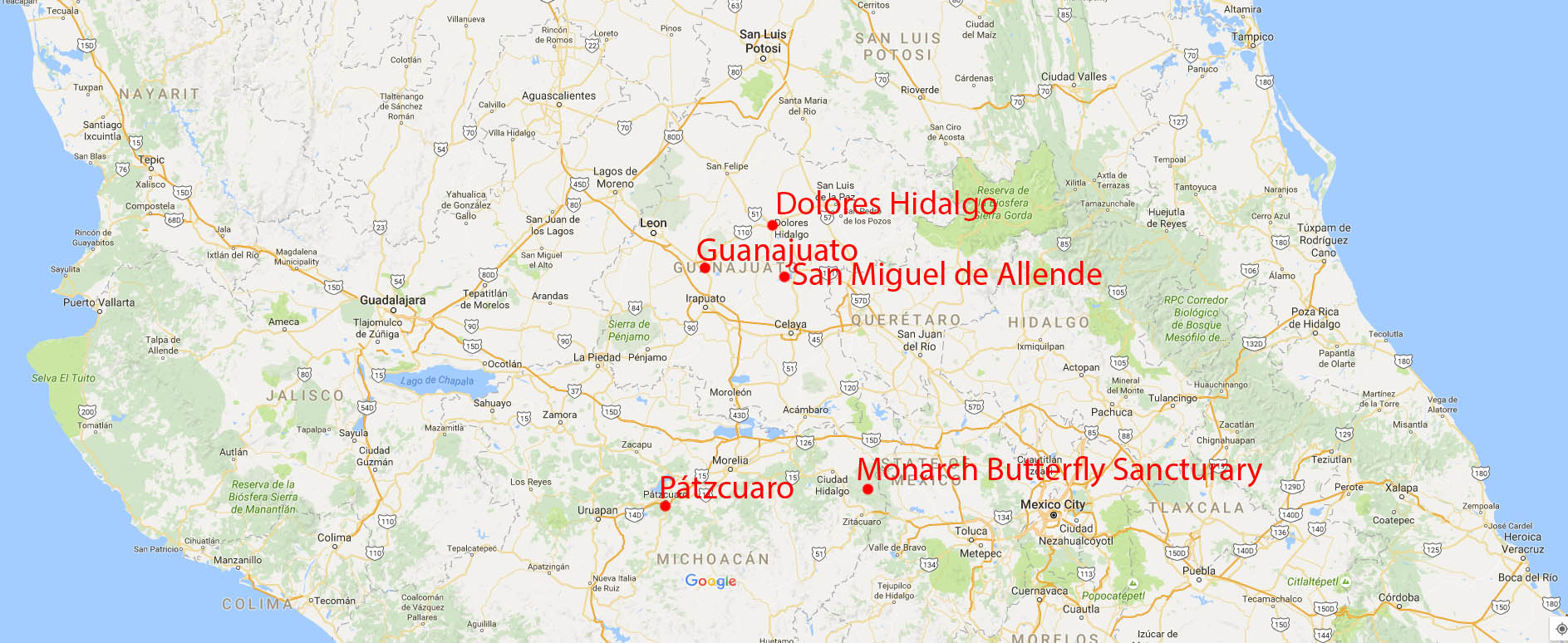
I plan to visit two Mexican states: Guanajuato and Michoacán, north and west of Mexico City and both with rich histories in the colonial period and in the struggle for independence from Spain.
I’m not a resort person. The idea of lying on a beach and drinking all day doesn’t interest me, though a day or two of that can be fun. No time for that this trip. My interests are in photography and exploring the history and culture. So, I plan to stay in just four colonial cities (not counting Tijuana), all of which I’ve been to either in 1993 or 2003: Guanajuato, Dolores Hidalgo, San Miguel de Allende and Pátzcuaro.
The only place I’ve never been to that is on my itinerary is a sanctuary high in the mountains of Michoacán that is the winter home of the monarch butterflies, who migrate there all the way from eastern Canada.
On Monday, I’ll be driving over the Allison Pass to the B.C. Lower Mainland, then getting my flight out very early Tuesday morning. A stopover in Salt Lake City then on to San Diego, crossing to Mexico Wednesday morning. I’d better get there before “The Wall” is built.
I spotted this young grizzly bear eating vegetation on the shoulder of the Alaska Highway just east of Haines Junction, Yukon. I watched discretely from my car on the opposite shoulder of the road and the bear saw me, but kept on eating. Only when some people in an RV pulled up a few feet away from it and called to it did it take off into the bush. (Richard McGuire photo)
Written Wednesday, June 8, 2016
Normally you start driving the Alaska Highway at Mile 0 in Dawson Creek and you head north. Because I’d come up to the Yukon by the Cassiar Highway, my trip took me down the highway from Haines Junction in the opposite direction.
Haines Junction is at Kilometre 1,632 by today’s count, or at historic Mile 1,016.
When the Alaska Highway was built in 1942 during World War II, the U.S. Army engineers and surveyors were in a rush to get it completed in order to supply Alaska and prevent a Japanese invasion. Sometimes the bulldozers were nipping at their ankles as they surveyed, so the routes chosen weren’t always the best or most direct.
Over the years, since Canada took over the highway after the war in 1946, it has been continually upgraded and in places the route has been shortened. So today’s measurement in kilometres isn’t an exact conversion of the original mileage markers. Still, the old mileage designations persist to identify places.
The community of Wonowon, for example, was built at the original Mile 101. It was never renamed to Kilometre 160.
My first trip up and down the Alaska Highway was hitchhiking as a teenager in 1971. In those days most of the highway beyond Fort St. John was gravel. When it was dry, there was constant thick dust from any vehicles ahead. When it rained for several days at a time, as it did when I travelled it, the highway was covered in puddles, holes and mud at the edges.
These days it’s mostly a good two-lane highway, and many parts have narrow shoulders. Because of the shifting frost, there are frequent bumps, and many parts are under repair, sometimes with large areas scraped down to the gravel, recreating the feeling of the old days.
In the Yukon, there were often orange flags placed beside bad spots, but you saw these flags all the time and never knew if it was just a minor bump or a big one that would scrape the undercarriage of your car. I had a couple scrapes when I didn’t take the flags seriously enough.
I left the lodge at Haines Junction early in the morning Tuesday, planning to get a good start on the day and cover a lot of ground. Driving in the early morning, you also tend to see a lot more animals by the road.
Not far out of Haines Junction, I spotted a young grizzly bear eating vegetation on the other side of the highway. I stopped and pulled over, remaining in my car of course, and moving slowly. It saw me, but kept on eating and didn’t seem perturbed as I shot several photos with a long lens. Only when some tourists in an RV pulled up a few feet away from it and called to it did it scramble off into the bush.
I always tried to keep a respectful distance from any wildlife and never to approach them except along the road in my vehicle. I also moved slowly and stayed quiet, just observing from my vehicle with the long lens.
Not so for all tourists. I actually saw a whole group of vehicles stopped next to a full-grown grizzly that was eating by the highway. One woman was out of her car taking photos of it with her iPad. Aside from the silliness of taking photos with an iPad, what was this woman thinking??? If that grizzly suddenly felt threatened and charged her, she could have been in a life-threatening situation.
I’d driven portions of the Alaska Highway on my trip from the top of the Cassiar Highway to Haines Junction on the way up, but after I passed the top of the Cassiar again on the return, I was covering all new ground. The next stop was Watson Lake.
Watson Lake is just under 1,500 people, but that still makes it one of the largest communities on the Yukon portion of the Alaska Highway after Whitehorse, with just under 30,000, which is where more than three quarters of the people in the territory live.
Watson Lake’s claim to fame is the Sign Post Forest. This started in 1942 when a homesick GI working on the highway posted a mileage sign to his home in Danville, IL, giving its distance as 2,835 miles. Soon more signs were added, and they continue to be put up on posts every day so that now there are more than 100,000 city signs, distance signs, license plates, and personal message signs. It truly is a forest of them, and more expansive than I expected.
There are signs from all over the world. I looked for obscure places I’ve lived and visited, but was surprised by what I saw and didn’t see. Of course I may have missed some places in the forest, but I never saw Osoyoos, or larger cities where I’ve lived or visited such as Toronto, Ottawa, Montreal or Edmonton. I did, however, see a lot of suburbs of those big cities as well as smaller communities.
From my Ottawa days, I spotted Almonte, Ontario, named for Mexican General Juan Almonte, but pronounced AL-mont.
Even more surprising, I spotted the Ottawa Valley village of Ompah, that few would know, because it’s on a back road and you miss it if you blink. (I used to annoy Victoria by calling it Oom-pah-pah).
The Alaska Highway certainly has many beautiful parts with lakes, rivers and snowcapped mountains. But it also has many parts of nondescript boreal forest with mile after mile of spruce and aspen trees lining the highway.
It got particularly beautiful though as the highway crossed into B.C. and followed the Liard River, then entered the Northern Rocky Mountains. I also had more black bear sightings, and even some wood bison, that have been reintroduced to the area after they were previously extirpated. Unfortunately I couldn’t stop when I passed a whole group of wood bison with their small youngsters because it was in the middle of a construction zone.
Tuesday had the best weather of my trip so far with only a few brief periods of rain. So I decided to camp at Muncho Lake Provincial Park in the Northern Rockies. The site beside the lake was spectacular. I got up at 4 a.m. to catch the early morning light, get a good start on the day and see more animals along the roadside.
Bison, bears, moose, deer, a porcupine and dall sheep were among the animals I spotted Wednesday morning.
There were several major thunderstorms with the sky opening up and with visibility and road conditions so bad that I had to pull off and wait for it to clear up. At last, in soaking rain, I arrived at Dawson Creek and Mile 0 of the Alaska Highway.
I spotted this young grizzly bear eating vegetation on the shoulder of the Alaska Highway just east of Haines Junction, Yukon. I watched discretely from my car on the opposite shoulder of the road and the bear saw me, but kept on eating. Only when some people in an RV pulled up a few feet away from it and called to it did it take off into the bush. (Richard McGuire photo)The Sign Post Forest at Watson Lake, Yukon has more than 100,000 place signs, distance signs, license plates and other signage left on posts by visitors from all over the world. It was started in 1942 by a homesick GI from Danville, IL, indicating 2,835 miles to his home town. Over the years it has grown so it it now is virtually a forest of signs. (Richard McGuire photo)The Sign Post Forest at Watson Lake, Yukon has more than 100,000 place signs, distance signs, license plates and other signage left on posts by visitors from all over the world. It was started in 1942 by a homesick GI from Danville, IL, indicating 2,835 miles to his home town. Over the years it has grown so it it now is virtually a forest of signs. (Richard McGuire photo)The Sign Post Forest at Watson Lake, Yukon has more than 100,000 place signs, distance signs, license plates and other signage left on posts by visitors from all over the world. It was started in 1942 by a homesick GI from Danville, IL, indicating 2,835 miles to his home town. Over the years it has grown so it it now is virtually a forest of signs. (Richard McGuire photo)The Sign Post Forest at Watson Lake, Yukon has more than 100,000 place signs, distance signs, license plates and other signage left on posts by visitors from all over the world. It was started in 1942 by a homesick GI from Danville, IL, indicating 2,835 miles to his home town. Over the years it has grown so it it now is virtually a forest of signs. (Richard McGuire photo)The Sign Post Forest at Watson Lake, Yukon has more than 100,000 place signs, distance signs, license plates and other signage left on posts by visitors from all over the world. It was started in 1942 by a homesick GI from Danville, IL, indicating 2,835 miles to his home town. Over the years it has grown so it it now is virtually a forest of signs. (Richard McGuire photo)I spotted this black bear eating vegetation on the opposite side of the Alaska Highway from me. It saw me, but kept on eating as I watched with a long lens. This was taken in northern B.C. just south of the Yukon border near the Liard River. (Richard McGuire photo)This wood bison was grazing beside the Alaska Highway in northern B.C. in the Liard River area, just south of the Yukon border. They were extirpated, but have been reintroduced to the area. (Richard McGuire photo)I spotted this black bear eating vegetation on the opposite side of the Alaska Highway from me. It saw me, but kept on eating as I watched with a long lens. This was taken in northern B.C. just south of the Yukon border near the Liard River. (Richard McGuire photo)I spotted this black bear eating vegetation on the opposite side of the Alaska Highway from me. It saw me, but kept on eating as I watched with a long lens. This was taken in northern B.C. just south of the Yukon border near the Liard River. (Richard McGuire photo)The Alaska Highway skirts the Liard River in northern B.C. near the Yukon border. (Richard McGuire photo)Muncho Lake Provincial Park in northern B.C. along the Alaska Highway offers some spectacular scenery as the highway passes through the Northern Rocky Mountains. (Richard McGuire photo)Muncho Lake Provincial Park in northern B.C. along the Alaska Highway offers some spectacular scenery as the highway passes through the Northern Rocky Mountains. (Richard McGuire photo)I tented at Mucho Lake Provincial Park on the Alaska Highway in the Northern Rocky Mountains, and I got up at 4 a.m. to catch the early light over Muncho Lake. (Richard McGuire photo)I tented at Mucho Lake Provincial Park on the Alaska Highway in the Northern Rocky Mountains, and I got up at 4 a.m. to catch the early light over Muncho Lake. (Richard McGuire photo)I tented at Mucho Lake Provincial Park on the Alaska Highway in the Northern Rocky Mountains, and I got up at 4 a.m. to catch the early light over Muncho Lake. (Richard McGuire photo)I tented at Mucho Lake Provincial Park on the Alaska Highway in the Northern Rocky Mountains, and I got up at 4 a.m. to catch the early light over Muncho Lake. (Richard McGuire photo)I tented at Mucho Lake Provincial Park on the Alaska Highway in the Northern Rocky Mountains, and I got up at 4 a.m. to catch the early light over Muncho Lake. (Richard McGuire photo)I tented at Mucho Lake Provincial Park on the Alaska Highway in the Northern Rocky Mountains, and I got up at 4 a.m. to catch the early light over Muncho Lake. (Richard McGuire photo)I tented at Mucho Lake Provincial Park on the Alaska Highway in the Northern Rocky Mountains, and I got up at 4 a.m. to catch the early light over Muncho Lake. (Richard McGuire photo)This female moose was grazing next to the Alaska Highway in Muncho Lake Provincial Park in northern B.C. This was taken near the Toad River. (Richard McGuire photo)Porcupines aren’t the fastest of creatures, but they use their quills rather than speed as defence against predators. I was able to take a few shots of this one by the Alaska Highway before it waddled off into the bush. (Richard McGuire photo)This dall sheep (stone sheep) was waiting for me at a pullout by the Alaska Highway near McDonald Creek in northern B.C. It actually approached me a little bit before climbing down a steep embankment that only a sheep could handle. (Richard McGuire photo)This is the official cairn for the start of the Alaska Highway, or Mile 0, in Dawson Creek, B.C. The more photographed marker is a couple blocks away. (Richard McGuire photo)This is the more photographed, unofficial start of the Alaska Highway, or Mile 0, in Dawson Creek, B.C. The official cairn is a couple blocks away. (Richard McGuire photo)This is the more photographed, unofficial start of the Alaska Highway, or Mile 0, in Dawson Creek, B.C. The official cairn is a couple blocks away. (Richard McGuire photo)
The Haines Highway south of Haines Junction passes by many beautiful lakes and mountains. (Richard McGuire photo)
Written Monday, June 6, 2016
Today was the sunniest day of my entire vacation, with only a tiny bit of drizzle when I was at higher elevation. The winds though were extremely strong.
I was up early and headed out to enjoy the views of the mountains in the sunlight. I began with a drive south on Highway 3, the Haines Highway, from Haines Junction. It ultimately leads to Haines, Alaska, but I stopped a little before the border and didn’t go all the way.
You rise in elevation, entering B.C. as you cross south of the 60th Parallel. In B.C., you leave Kluane National Park and skirt Tatshenshini Alsek Provincial Park. It was chilly at Haines Highway Summit and there were many patches of snow on the ground and even more on the sides of the mountains.
Back at Haines Junction, I took a look at Our Lady of the Way, a small Catholic church built in 1954 in a Quonset hut, which was what was available at the time.
I then went for a hike of about 13 km return into the Alsek Valley. I brought bear spray, but had no encounters with any mammals at all — not even ground squirrels.
It was an easy walk along a 4X4 track crossing alluvial plains and several streams. It was soothing to get out in nature with just the mountains around and only the sound of the powerful wind.
Mountains along the Alaska Highway west of Haines Junction. (Richard McGuire photo)Quill Creek, south of Haines Junction. (Richard McGuire photo)Kathleen Lake, south of Haines Junction, Yukon. (Richard McGuire photo)The Haines Highway south of Haines Junction passes by many beautiful lakes and mountains. (Richard McGuire photo)The Haines Highway south of Haines Junction passes by many beautiful lakes and mountains. (Richard McGuire photo)The Haines Highway south of Haines Junction passes by many beautiful lakes and mountains. (Richard McGuire photo)The Haines Highway south of Haines Junction passes by many beautiful lakes and mountains. (Richard McGuire photo)Driving south on the Haines Highway from Haines Junction, the route passes into B.C. and skirts Tatshenshini Alsek Park. (Richard McGuire photo)Driving south on the Haines Highway from Haines Junction, the route passes into B.C. and skirts Tatshenshini Alsek Park. (Richard McGuire photo)Driving south on the Haines Highway from Haines Junction, the route passes into B.C. and skirts Tatshenshini Alsek Park. (Richard McGuire photo)Driving south on the Haines Highway from Haines Junction, the route passes into B.C. and skirts Tatshenshini Alsek Park. (Richard McGuire photo)Driving south on the Haines Highway from Haines Junction, the route passes into B.C. and skirts Tatshenshini Alsek Park. (Richard McGuire photo)Driving south on the Haines Highway from Haines Junction, the route passes into B.C. and skirts Tatshenshini Alsek Park. (Richard McGuire photo)Driving south on the Haines Highway from Haines Junction, the route passes into B.C. and skirts Tatshenshini Alsek Park. (Richard McGuire photo)Driving south on the Haines Highway from Haines Junction, the route passes into B.C. and skirts Tatshenshini Alsek Park. (Richard McGuire photo)The small Catholic church Our Lady of the Way in Haines Junction was built in 1954 from a quonset hut. These were common from the period of the Alaska Highway construction. (Richard McGuire photo)I took a short hike into the Alsek Valley west of Haines Junction. (Richard McGuire photo)I took a short hike into the Alsek Valley west of Haines Junction. (Richard McGuire photo)
It was a rainy day when I drove to Haines Junction. That evening I went for a drive up to Destruction Bay on Kluane Lake, skirting Kluane National Park. The sun gradually emerged from the clouds, creating some dramatic weather. (Richard McGuire photo)
Written Sunday, June 5, 2016
I left Carcross late, glad that I had taken the trip to Skagway yesterday when the weather was so beautiful. It was another day of clouds and rain.
Other than stopping for groceries in Whitehorse, I mostly drove through less interesting scenery until I reached Haines Junction.
I’m staying in a friendly lodge, getting a break on the price because the bathroom with my room isn’t finished so I’m using a shared bathroom. It’s a more social atmosphere than staying in a motel or camping.
I decided to take a drive in the evening up to Destruction Bay on Kluane Lake, following the Alaska Highway as it skirts Kluane National Park. It was a good decision. Though it was grey and raining when I started out, I met the sun along the way.
Sometimes the most dramatic landscapes are just as the weather is changing. By the time I got to Destruction Bay, the sun was out. When I returned, the sun was moving in the direction of Haines Junction.
I hope that means better weather tomorrow when I explore the national park and the area along Highway 3, which heads down to Haynes, Alaska, though I don’t think I’ll go that far. I’ll be here again tomorrow night before I begin the journey home.
Emerald Lake north of Carcross, Yukon takes on a bluish emerald colour as a result of the marl on its bottom. (Richard McGuire photo)It was a rainy day when I drove to Haines Junction. That evening I went for a drive up to Destruction Bay on Kluane Lake, skirting Kluane National Park. The sun gradually emerged from the clouds, creating some dramatic weather. (Richard McGuire photo)It was a rainy day when I drove to Haines Junction. That evening I went for a drive up to Destruction Bay on Kluane Lake, skirting Kluane National Park. The sun gradually emerged from the clouds, creating some dramatic weather. (Richard McGuire photo)It was a rainy day when I drove to Haines Junction. That evening I went for a drive up to Destruction Bay on Kluane Lake, skirting Kluane National Park. The sun gradually emerged from the clouds, creating some dramatic weather. (Richard McGuire photo)It was a rainy day when I drove to Haines Junction. That evening I went for a drive up to Destruction Bay on Kluane Lake, skirting Kluane National Park. The sun gradually emerged from the clouds, creating some dramatic weather. (Richard McGuire photo)It was a rainy day when I drove to Haines Junction. That evening I went for a drive up to Destruction Bay on Kluane Lake, skirting Kluane National Park. The sun gradually emerged from the clouds, creating some dramatic weather. (Richard McGuire photo)It was a rainy day when I drove to Haines Junction. That evening I went for a drive up to Destruction Bay on Kluane Lake, skirting Kluane National Park. The sun gradually emerged from the clouds, creating some dramatic weather. (Richard McGuire photo)This old International truck was parked at Destruction Bay, Yukon and didn’t seem to be headed anywhere soon. (Richard McGuire photo)It was a rainy day when I drove to Haines Junction. That evening I went for a drive up to Destruction Bay on Kluane Lake, skirting Kluane National Park. The sun gradually emerged from the clouds, creating some dramatic weather. (Richard McGuire photo)It was a rainy day when I drove to Haines Junction. That evening I went for a drive up to Destruction Bay on Kluane Lake, skirting Kluane National Park. The sun gradually emerged from the clouds, creating some dramatic weather. (Richard McGuire photo)It was a rainy day when I drove to Haines Junction. That evening I went for a drive up to Destruction Bay on Kluane Lake, skirting Kluane National Park. The sun gradually emerged from the clouds, creating some dramatic weather. (Richard McGuire photo)It was a rainy day when I drove to Haines Junction. That evening I went for a drive up to Destruction Bay on Kluane Lake, skirting Kluane National Park. The sun gradually emerged from the clouds, creating some dramatic weather. (Richard McGuire photo)It was a rainy day when I drove to Haines Junction. That evening I went for a drive up to Destruction Bay on Kluane Lake, skirting Kluane National Park. The sun gradually emerged from the clouds, creating some dramatic weather. (Richard McGuire photo)It was a rainy day when I drove to Haines Junction. That evening I went for a drive up to Destruction Bay on Kluane Lake, skirting Kluane National Park. The sun gradually emerged from the clouds, creating some dramatic weather. (Richard McGuire photo)It was a rainy day when I drove to Haines Junction. That evening I went for a drive up to Destruction Bay on Kluane Lake, skirting Kluane National Park. The sun gradually emerged from the clouds, creating some dramatic weather. (Richard McGuire photo)It was a rainy day when I drove to Haines Junction. That evening I went for a drive up to Destruction Bay on Kluane Lake, skirting Kluane National Park. The sun gradually emerged from the clouds, creating some dramatic weather. (Richard McGuire photo)
One of the nice things for photographers in June in the Yukon is the long golden hours. I took this photo south of Carcross at 10 p.m. It wasn’t dark until after midnight. (Richard McGuire photo)
Written Saturday, June 4, 2016
One of the great things about being in the Yukon is the 18+ hours of daylight.
Today was the best weather of my trip so far, with only a few sprinkles of rain and with quite a bit of sunshine. The mountains light up, especially in the golden hours of late evening.
Yesterday, Friday, I drove up much of the Cassiar Highway leaving Stewart and reaching Boya Lake Provincial Park in the north of B.C.
It rained most of the day, but later in the afternoon the sunshine came out, again forming rainbows.
The Cassiar Highway is very wild. There are passing trucks and a few RVs, but mostly it’s an empty highway with spreading wilderness and snowy mountains all around. You pass lakes and rivers and frequently see black bears munching on vegetation at the side of the road.
As the rain was no more than an occasional drizzle by late afternoon, I decided to camp at Boya Lake Provincial Park. Despite a bit of rain during the night, I stayed dry.
The golden evening light on the lake and mountains made Boya Lake an idyllic spot, and I envied the people camping there for a longer time. I was almost tempted to take up fishing.
This morning, I continued up though a vast area once burned out by a forest fire leaving spindly dead trees sticking up for miles around.
At last, I crossed the 60th parallel into Yukon.
The Alaska Highway is now paved and widened from when I last took it as a hitchhiking teen in 1971. In those days it was dirty and dusty and gravel all the way.
Frequent road work today stripped the highway down to gravel, kicking up clouds of dust and reminding me of the earlier time.
At Jake’s Corners, I turned off onto Highway 8 to make for Carcross, where I decided to stay the night. Carcross is an abbreviation of the former name Caribou Crossing.
The scenery is spectacular with lakes, mountains and even the famous Carcross Desert, said to be the world’s smallest desert, but actually just an area of large sand dunes left behind by a receding glacial lake.
There are also many old Klondike era cabins, still standing, though barely.
At the tourist office, a helpful woman suggested I take advantage of the sunshine that day and the long hours of sunlight to drive the Skagway Highway that evening. It was great advice, especially since the weather was going to take another turn for the worse tomorrow.
The highway to Skagway is certainly one of the most beautiful drives in the world, and I kept pulling off to take pictures of lakes, mountains, glaciers and the occasional bear.
Crossing into Alaska, I made the long descent into Skagway, the northern port for ships on the Inside Passage. It’s definitely a tourist town, but it still has many of the old wooden buildings from the Klondike era, converted into restaurants, bars, boutiques and even a brothel museum (closed when I was there).
The drive from Carcross to Skagway as a little over an hour, though much longer with frequent photo stops. I spent about an hour in Skagway, then made the trip back to Carcross, all the time in daylight, even though it was late evening.
By the time I got back to my motel and got ready for bed it was past midnight and still lightish outside.
Tomorrow I’m off to Haines Junction near Kluane National Park.
These purple lupins were growing in many places along the Cassiar Highway. (Richard McGuire photo)This black bear was munching on vegetation beside the Cassiar Highway. I stayed safely in my car as I photographed her. She glanced at me, but didn’t seem perturbed, though she made her way slowing into the bushes. She was a magnet for insects. (Richard McGuire photo)I stopped at the Rabid Grizzly rest stop to cook myself some dinner. Some of the place names along the Cassiar Highway might bring nightmares to ursaphobes. (Richard McGuire photo)I camped at Boya Lake Provincial Park off the north part of the Cassiar Highway. This boat tied up on the shore was almost enough to make me take up fishing. (Richard McGuire photo)A forest fire a number of years ago left spindles of dead trees over a large area, seem behind this peaceful lake off the Cassiar Highway. (Richard McGuire photo)On the Alaska Highway the road stretches though miles of wilderness with snow covered mountains all around. (Richard McGuire photo)A short walk to this waterfall at Rancheria Falls off the Alaska Highway provided a break from driving. (Richard McGuire photo)It’s easy to lose track of your speed if you don’t keep looking at your spedometer on the open roads of the Yukon. This cutout of an RCMP cruiser looks like the real thing from the distance and encourages people to slow down when passing through Teslin. (Richard McGuire photo)This handyman’s special at Carcross, Yukon needs a little TLC. There are a number of these old cabins surviving from the Klondike era along the river. Carcross is an abbreviation of the original name Caribou Crossing. (Richard McGuire photo)This narrow gauge railway runs from Skagway, Alaska to Carcross, Yukon. This is the bridge at Carcross. (Richard McGuire photo)Carcross boasts the world’s smallest desert. It’s actually sand dunes left behind by a shrinking glacial lake. (Richard McGuire photo)Carcross boasts the world’s smallest desert. It’s actually sand dunes left behind by a shrinking glacial lake. (Richard McGuire photo)The drive from Carcross, Yukon to Skagway, Alaska is only a little over an hour (minus numerous photo stops), but it’s one of the most beautiful drives in the world. It gets chilly as you climb through White Pass. (Richard McGuire photo)The drive from Carcross, Yukon to Skagway, Alaska is only a little over an hour (minus numerous photo stops), but it’s one of the most beautiful drives in the world. It gets chilly as you climb through White Pass. (Richard McGuire photo)The drive from Carcross, Yukon to Skagway, Alaska is only a little over an hour (minus numerous photo stops), but it’s one of the most beautiful drives in the world. It gets chilly as you climb through White Pass. (Richard McGuire photo)The drive from Carcross, Yukon to Skagway, Alaska is only a little over an hour (minus numerous photo stops), but it’s one of the most beautiful drives in the world. It gets chilly as you climb through White Pass. (Richard McGuire photo)The drive from Carcross, Yukon to Skagway, Alaska is only a little over an hour (minus numerous photo stops), but it’s one of the most beautiful drives in the world. It gets chilly as you climb through White Pass. (Richard McGuire photo)The customs posts aren’t right at the border, but this welcome sign greets travellers entering Alaska on the drive from Carcross, Yukon. (Richard McGuire photo)It’s definitely a tourist town as the northern port for ships travelling the Inside Passage, but Skagway, Alaska has a unique charm with many older wooden buildings surviving from the Klondike era. This house of negotiable affection appeared to be closed when I came by. (Richard McGuire photo)It’s definitely a tourist town as the northern port for ships travelling the Inside Passage, but Skagway, Alaska has a unique charm with many older wooden buildings surviving from the Klondike era. (Richard McGuire photo)It’s definitely a tourist town as the northern port for ships travelling the Inside Passage, but Skagway, Alaska has a unique charm with many older wooden buildings surviving from the Klondike era. (Richard McGuire photo)
When you cross the international border from B.C. into Hyder, Alaska, there is no U.S. customs station. (Richard McGuire photo)
Written Thursday, June 2, 2016
Today I crossed the international border four times and only stopped at customs once.
Hyder, Alaska, as I noted to one local, is the second quirkiest border crossing on the entire length of the Canada-U.S. border.
She looked at me puzzled: “Second? What’s the first?”
Stanstead, Quebec and Derby Line, Vermont, I told her. But that’s a different story.
Nonetheless, Hyder, as a border crossing and a community of about 100 people calling itself, “The Friendliest Ghost Town in Alaska,” is pretty quirky.
There are no U.S. customs authorities. In fact there are no authorities of any kind unless someone commits a murder or something and they have to bring them in from elsewhere.
The RCMP cross the border from time to time to do courtesy patrols, but they don’t have jurisdiction to do anything other than report any problems to distant U.S. authorities.
The only sign of customs authorities is the Canada Border Services Agency post in an Atco trailer when you return from Hyder to Canada. They just don’t want any cheap Yankee booze, illegal firearms or marijuana coming into Canada.
As you leave Hyder to return to Canada, someone with a sense of humour put up a sign in English, French and German: “Checkpoint Charlie: You are leaving the American sector.” Shades of cold war Berlin.
Down the road a little as you enter Hyder, you pass the Glacier Inn on the left, which has a big sign: “Get Hyderized.” The tradition since the 1950s is you pour back a shot of 190 proof grain alcohol and they give you a card proving your achievement. I gave this tradition a pass as I had driving to do.
Caroline, who runs a gift shop and was standing in front smoking a cigarette, started a conversation. She’s been in Hyder nearly 40 years. It’s not for everyone, she said, but she loves it. She’s out of her element when she goes to a city.
I asked her about the border.
Caroline told me that once the Canadian authorities got the brilliant idea to close the customs post at night, which effectively trapped the people in Hyder. There’s no other way out by land to anywhere except through Canada. This created a bad situation in cases of medical emergency.
People in Hyder use the 250 B.C. area code. Their electricity comes from B.C. Hydro. They send their kids to school over the border in Stewart. They use Pacific Time like B.C., even though a former postmaster insisted in going by the book and using Alaska time.
“We’re two countries, but one community,” said Caroline.
I stopped in at the post office to mail a postcard I’d bought in Caroline’s shop. The young woman postmaster was not the same one as the “by-the-books” one, who apparently was two before her.
I asked if by any chance she had the new National Park stamps, which include my photo of Carlsbad Caverns. She said she thought she did, and she checked the release date. June 1. She could sell me a sheet of the entire series.
She was impressed and almost unbelieving when I told her I’d taken the photo on the stamp and she asked me about it. I gave her a copy of the OK Sun that had Lyonel Doherty’s story about it.
I don’t believe they sell that stamp individually, but I’ll order a set of first-day covers when I have a chance.
Next I headed north of Hyder on a road that leads to a couple mines, but of more interest it crosses back into B.C. just before the spectacular Salmon Glacier.
This crossing has no customs in either direction. The only indication of the border is a welcome to B.C. sign, a small metal border marker cone in the brush, and a long strip cleared of vegetation stretching along the border over the hills. They apparently clear the brush every 10 years.
Salmon Glacier extends as a long tongue down a valley to just above a lake. Like Bear Glacier, it was once longer, but with climate change it is melting. It was still very impressive to look down on it from the gravel road high above.
Back into Alaska and there wasn’t even a welcome sign. My third border crossing and still no customs.
Only when I got back to Checkpoint Charlie did I have to stop, returning into Canada.
She asked me the usual questions, and then got to the one about firearms and weapons. I always just say “no,” but then she asked me specifically about bear spray, which I had.
As long as you have it for bears and not humans, it’s legal. She smiled and told me that clearly there was a reason to have it in these parts. There are bears everywhere.
I did see one black bear beside the road, but no grizzlies. At Fish Creek north of Hyder there’s an observation spot where you can get a great view of grizzlies fishing for salmon, but it was still a bit early in the season for them.
Back in Stewart, it was still pouring rain, but the most brilliant sun I’ve seen since I left Osoyoos was beaming through the clouds. It was almost blinding as I wasn’t used to it. A rainbow floated above Stewart’s main street, and it remained on and off for well over an hour.
I hope it portends better weather as I head back north tomorrow up the Cassiar.
A fishing boat makes its way out from Stewart harbour into the Portland Canal, an arm of the Pacific Ocean. (Richard McGuire photo)OClouds drift over the harbour at Stewart, B.C. (Richard McGuire photo)A black bear strolls next to the roadway between Stewart, B.C. and Hyder, Alaska. (Richard McGuire photo)When you cross the international border from B.C. into Hyder, Alaska, there is no U.S. customs station. (Richard McGuire photo)Hyder, Alaska claims to be the state’s friendliest ghost town. There are fewer than 100 residents and it’s hard to tell if many of the buildings are abandoned or just closed for the season. (Richard McGuire photo)The people of Hyder, Alaska definitely have a sense of humour. There’s no customs post entering Hyder from Canada, but there is one in an Atco trailer when you return to Canada. Somebody saw a similarity to crossing from West Berlin to East Berlin in the cold war era. (Richard McGuire photo)Anyone thinking of crossing the border for cheap U.S. gas in Hyder, Alaska will probably be disappointed. (Richard McGuire photo)St. Paul’s Orthodox Church in Hyder, Alaska is a modest building compared to some churches. (Richard McGuire photo)It’s sometimes hard to tell if businesses in Hyder, Alaska are permanently closed or just closed for the season. (Richard McGuire photo)The tradition in Hyder is to “get Hyderized” by gulping back a shot of 190 proof grain alcohol. For that you receive a card attesting to your accomplishment. I gave this tradition a pass, in part because I was driving. (Richard McGuire photo)It’s sometimes hard to tell if businesses in Hyder, Alaska are permanently closed or just closed for the season. (Richard McGuire photo)This general store in Hyder, Alaska was closed for the season. A sign on the front boasts of the 100 happy people and a few old s— heads. (Richard McGuire photo)Hyder, Alaska was once a much bigger community than the 100 people who live there now. Many empty buildings attest to its claim to be Alaska’s friendliest ghost town. (Richard McGuire photo)Leaving Hyder, Alaska to go north, you pass by this wetland. (Richard McGuire photo)Leaving Hyder, Alaska to go north, you pass by this river. (Richard McGuire photo)A sign welcoming you to B.C., a border marker and a long line cleared of vegetation every 10 years are the only indications you have crossed an international border north of Hyder, Alaska on the way to Salmon Glacier in British Columbia. (Richard McGuire photo)A sign welcoming you to B.C., a border marker and a long line cleared of vegetation every 10 years are the only indications you have crossed an international border north of Hyder, Alaska on the way to Salmon Glacier in British Columbia. (Richard McGuire photo)A sign welcoming you to B.C., a border marker and a long line cleared of vegetation every 10 years are the only indications you have crossed an international border north of Hyder, Alaska on the way to Salmon Glacier in British Columbia. (Richard McGuire photo)Salmon Glacier snakes down a valley in B.C. just north of Hyder, Alaska. You drive up to about 1,000 metres in elevation, and there was still a considerable amount of snow at the roadside, although it was quickly melting. (Richard McGuire photo)Salmon Glacier snakes down a valley in B.C. just north of Hyder, Alaska. You drive up to about 1,000 metres in elevation, and there was still a considerable amount of snow at the roadside, although it was quickly melting. (Richard McGuire photo)Salmon Glacier snakes down a valley in B.C. just north of Hyder, Alaska. You drive up to about 1,000 metres in elevation, and there was still a considerable amount of snow at the roadside, although it was quickly melting. (Richard McGuire photo)Salmon Glacier snakes down a valley in B.C. just north of Hyder, Alaska. You drive up to about 1,000 metres in elevation, and there was still a considerable amount of snow at the roadside, although it was quickly melting. (Richard McGuire photo)Salmon Glacier snakes down a valley in B.C. just north of Hyder, Alaska. You drive up to about 1,000 metres in elevation, and there was still a considerable amount of snow at the roadside, although it was quickly melting. (Richard McGuire photo)Salmon Glacier snakes down a valley in B.C. just north of Hyder, Alaska. You drive up to about 1,000 metres in elevation, and there was still a considerable amount of snow at the roadside, although it was quickly melting. (Richard McGuire photo)Salmon Glacier snakes down a valley in B.C. just north of Hyder, Alaska. You drive up to about 1,000 metres in elevation, and there was still a considerable amount of snow at the roadside, although it was quickly melting. (Richard McGuire photo)Salmon Glacier snakes down a valley in B.C. just north of Hyder, Alaska. You drive up to about 1,000 metres in elevation, and there was still a considerable amount of snow at the roadside, although it was quickly melting. (Richard McGuire photo)Salmon Glacier snakes down a valley in B.C. just north of Hyder, Alaska. You drive up to about 1,000 metres in elevation, and there was still a considerable amount of snow at the roadside, although it was quickly melting. (Richard McGuire photo)Salmon Glacier snakes down a valley in B.C. just north of Hyder, Alaska. You drive up to about 1,000 metres in elevation, and there was still a considerable amount of snow at the roadside, although it was quickly melting. (Richard McGuire photo)Salmon Glacier snakes down a valley in B.C. just north of Hyder, Alaska. You drive up to about 1,000 metres in elevation, and there was still a considerable amount of snow at the roadside, although it was quickly melting. (Richard McGuire photo)With lots of rain and with snow rapidly melting, there were lots of waterfalls by the road between Hyder, Alaska and Salmon Glacier in B.C. (Richard McGuire photo)When I got back to Stewart, B.C. after a visit to Hyder, Alaska, the sun emerged, but it continued to pour rain. A rainbow was visible over Stewart off and on for over an hour. (Richard McGuire photo)Late in the afternoon, sunlight broke through the clouds and rain lighting up the mountains above Stewart, B.C. (Richard McGuire photo)There are bears in abundance around the King Edward Hotel where I am staying in Stewart, B.C. (Richard McGuire photo)
Once a busy mining community, the quiet town of Stewart. B.C. sits in a spectacular location at the base of the mountains. Many of its old wooden buildings have a unique charm. (Richard McGuire photo)
Written June 1, 2016
The North Pacific Cannery at Port Edward was once a booming salmon cannery employing large numbers of Canadians separated by ethnicity for their accommodations and the work they performed.
Today it is a National Historic Site, museum and interpretive centre.
This was my first stop Wednesday after checking out of my motel in Prince Rupert. I’d tried to go Monday based on my guidebook saying it was open daily, but like the museum in Prince Rupert, it shuts down Mondays. Better luck this time.
I arrived just as a tour was leaving led by Lori, a First Nations woman who had grown up around the fishing industry. She now lives with her cats in one of the many cabins that once housed fishery workers.
First Nations workers as well as Canadians of European, Chinese and Japanese backgrounds worked at the plant in its heyday in the late 19th and early 20th centuries.
Lori showed us through the cabins where a large First Nations family might have lived in one room with a primitive toilet in the corner. At least it flushed twice a day when high tide came up, she said.
We toured the net loft where nets were hung to dry and community events were sometimes held. There was the rip-off company store where workers bought on credit and sometimes had to pay their entire season’s earnings to pay off their debts at the season’s end.
There was the rendering plant where workers had to wade deep in putrefying fish heads and guts, which decomposed for days before the oil was extracted for fish oil nutritional supplements and cosmetics and the solids were turned into pet food.
Back on the road, I retraced my route through Terrace and on to Kitwanga, the start of the Cassiar Highway.
My first stop not too far up the road was the First Nations village of Gitanyow, not a prosperous community by any means, but home to a beautiful collection of totem poles. Some of these are as old as a century and a half, and artistically, these were in a class above some of the others I’d seen. Painter Emily Carr used these ones as a source of inspiration.
It alternated between downpour and drizzle and back to downpour. I sometimes turned my wipers off for a minute or two, only to have to switch them on to high.
I had considered camping at Meziadin Junction where there is a provincial park at the turnoff for Stewart and Hyder, but just as a got to it, the sky opened up. There were a few motor homes, but no one was crazy enough to be camping in a tent. I wasn’t either.
I decided to continue on to Stewart, where I managed to find another basic room, discounted because it was above the kitchen of the King Edward Hotel and there was (minor) fan noise.
Stewart was once a booming mining town. There’s still some mining in the area, but these days tourism plays a larger role. The tourist season is only just beginning.
There are numerous old wooden buildings in various states of disrepair. Some have been restored for tourism while others continue to decay. Stewart is certainly a community with lots of character. And when the clouds break and you look up at the mountains towering above it with their snow and glaciers, it’s spectacular.
I’m here for two nights, and will visit Hyder, Alaska, three kilometres away, tomorrow.
The North Pacific Cannery at Port Edward just south of Prince Rupert is now a National Historic Site. Early in the last century though, it was a busy salmon cannery with a mixed labour force of First Nations and Canadians of European, Chinese and Japanese backgrounds. (Richard McGuire photo)The North Pacific Cannery at Port Edward just south of Prince Rupert is now a National Historic Site. Early in the last century though, it was a busy salmon cannery with a mixed labour force of First Nations and Canadians of European, Chinese and Japanese backgrounds. (Richard McGuire photo)The North Pacific Cannery at Port Edward just south of Prince Rupert is now a National Historic Site. Early in the last century though, it was a busy salmon cannery with a mixed labour force of First Nations and Canadians of European, Chinese and Japanese backgrounds. (Richard McGuire photo)At least all the rain and cloud keep the vegetation a lush green. The mountains along Highway 16 between Prince Rupert and Terrace have a unique beauty in the constant drizzle. (Richard McGuire photo)At Kitwanga, my journey left the relative civilization of Highway 16 to turn north on the Cassiar Highway, Highway 37, on a journey through about 900 km of wilderness to the Yukon, including a side trip to Stewart, B.C. and Hyder, Alaska. (Richard McGuire photo)They are artistic masterpieces and they inspired the painter Emily Carr, but the cluster of totem poles at Gitanyow are found in front of a humble gas bar in a not very prosperous First Nations community. They have stood for more than a century in some cases. (Richard McGuire photo)They are artistic masterpieces and they inspired the painter Emily Carr, but the cluster of totem poles at Gitanyow are found in front of a humble gas bar in a not very prosperous First Nations community. They have stood for more than a century in some cases. (Richard McGuire photo)They are artistic masterpieces and they inspired the painter Emily Carr, but the cluster of totem poles at Gitanyow are found in front of a humble gas bar in a not very prosperous First Nations community. They have stood for more than a century in some cases. (Richard McGuire photo)They are artistic masterpieces and they inspired the painter Emily Carr, but the cluster of totem poles at Gitanyow are found in front of a humble gas bar in a not very prosperous First Nations community. They have stood for more than a century in some cases. (Richard McGuire photo)The snowcapped Coast Mountains are seen to the west of the Cassiar Highway heading north from Kitwanga. (Richard McGuire photo)It’s a side trip of just over 60 km off the Cassiar Highway to the town of Stewart, B.C. The drive skirts the Coast Mountains. (Richard McGuire photo)It’s a side trip of just over 60 km off the Cassiar Highway to the town of Stewart, B.C. The drive skirts the Coast Mountains. (Richard McGuire photo)It’s a side trip of just over 60 km off the Cassiar Highway to the town of Stewart, B.C. The drive skirts the Coast Mountains and passes the dramatic Bear Glacier, which like so many glaciers is receding with climate change. (Richard McGuire photo)It’s a side trip of just over 60 km off the Cassiar Highway to the town of Stewart, B.C. The drive skirts the Coast Mountains and passes the dramatic Bear Glacier, which like so many glaciers is receding with climate change. (Richard McGuire photo)It’s a side trip of just over 60 km off the Cassiar Highway to the town of Stewart, B.C. The drive skirts the Coast Mountains. (Richard McGuire photo)Once a busy mining community, the quiet town of Stewart. B.C. sits in a spectacular location at the base of the mountains. Many of its old wooden buildings have a unique charm. (Richard McGuire photo)Once a busy mining community, the quiet town of Stewart. B.C. sits in a spectacular location at the base of the mountains. Many of its old wooden buildings have a unique charm. (Richard McGuire photo)Once a busy mining community, the quiet town of Stewart. B.C. sits in a spectacular location at the base of the mountains. Many of its old wooden buildings have a unique charm. (Richard McGuire photo)Once a busy mining community, the quiet town of Stewart. B.C. sits in a spectacular location at the base of the mountains. Many of its old wooden buildings have a unique charm. (Richard McGuire photo)Once a busy mining community, the quiet town of Stewart. B.C. sits in a spectacular location at the base of the mountains. Many of its old wooden buildings have a unique charm. (Richard McGuire photo)
A female grizzly bear stands up while eating sedge grass at Khutzeymateen Grizzly Bear Sanctuary. (Richard McGuire photo)
Written Tuesday, May 31, 2016
I took a short hike through rain forest and other landscapes down to the ocean at Butze Rapids Trail just outside Prince Rupert on Monday.
Otherwise it was a day to take care of a few chores before I leave civilization.
Today, I took a seven-hour boat tour to Khutzeymateen Grizzly Bear Sanctuary at the end of a long inlet north of Prince Rupert and close to the lower tip of Alaska. It poured rain off and on through the day, but this is the Great Bear Rain Forest after all. Clouds clung to snowcapped mountains beside the inlet.
We saw a few grizzly bears from the boat, but we never got very close. I wished I’d bought that $10,000 long lens I was admiring as my photos were poor resolution and grainy from the distance.
On the way back, we saw humpback whales diving, harbour seals chilling out on a rocky island and a group of bald eagles that swooped down when meat bits were thrown from the boat. The company that runs this tour is pretty responsible, and the guide explained that feeding the eagles doesn’t habituate them to humans as it would for some other animals — it’s just a treat for them.
Though I would have liked better weather and a chance to see the bears from closer, it was a worthwhile trip.
Tomorrow I head north up the Cassiar Highway and it’s iffy if I’ll have access to internet or cell from here onward for a few days.
Mosses hang from trees on the Butze Rapids Trail near Prince Rupert, B.C. (Richard McGuire photo)Plants grow up the side of a tree on the Butze Rapids Trail near Prince Rupert, B.C. (Richard McGuire photo)Labrador tea grows among a young pine on the Butze Rapids Trail near Prince Rupert, B.C. (Richard McGuire photo)New plants grow on top of a rotting stump on the Butze Rapids Trail near Prince Rupert, B.C. (Richard McGuire photo)Commercial fishing boats are moored at Rushbrook Harbour in Prince Rupert, B.C. (Richard McGuire photo)Rhododendrons grow in the Sunken Gardens in Prince Rupert, B.C. The gardens were put in the foundation dug for a courthouse that ended up being built rather east. (Richard McGuire photo)Clouds hang over the mountains that line the inlet approaching Khutzeymateen Grizzly Bear Sanctuary. There’s a reason they call this the Great Bear Rain Forest. (Richard McGuire photo)Clouds hang over the mountains that line the inlet approaching Khutzeymateen Grizzly Bear Sanctuary. There’s a reason they call this the Great Bear Rain Forest. (Richard McGuire photo)Clouds hang over the mountains that line the inlet approaching Khutzeymateen Grizzly Bear Sanctuary. There’s a reason they call this the Great Bear Rain Forest. (Richard McGuire photo)A young male grizzly bear makes his way through sedge grass at Khutzeymateen Grizzly Bear Sanctuary. (Richard McGuire photo)A young male grizzly bear makes his way along the shoreline at Khutzeymateen Grizzly Bear Sanctuary. (Richard McGuire photo)A humpback whale raises its tail from the water as it dives in the Pacific Ocean near Khutzeymateen Grizzly Bear Sanctuary. (Richard McGuire photo)Harbour seals chill out on a rocky island as they take a break from fishing in the Pacific Ocean near Khutzeymateen Grizzly Bear Sanctuary. (Richard McGuire photo)Harbour seals chill out on a rocky island as they take a break from fishing in the Pacific Ocean near Khutzeymateen Grizzly Bear Sanctuary. (Richard McGuire photo)A bald eagle swoops down for pieces of meat thrown from a tour boat near Prince Rupert, B.C. (Richard McGuire photo)A bald eagle swoops down for pieces of meat thrown from a tour boat near Prince Rupert, B.C. (Richard McGuire photo)A bald eagle swoops down for pieces of meat thrown from a tour boat near Prince Rupert, B.C. (Richard McGuire photo)A bald eagle swoops down for pieces of meat thrown from a tour boat near Prince Rupert, B.C. (Richard McGuire photo)A bald eagle swoops down for pieces of meat thrown from a tour boat near Prince Rupert, B.C. (Richard McGuire photo)